Crooked Lake Wetlands
No. 255
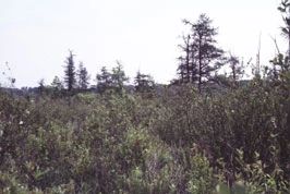
Photo by E. Epstein
Crooked Lake Wetlands is a diverse complex of communities including a northern wet forest, southern dry-mesic forest, southern sedge meadow, shrub-carr, open bog, and two shallow seepage lakes. The 65-acre Crooked Lake is one of the larger natural lakes in the county and has a maximum depth of 34 feet. The inlet provides a spawning ground for the northern pike while the outlet forms a small tributary of the East Branch of the Milwaukee River. On the west side of Crooked Lake is a shrub-carr of diverse composition and structure.
White meadowsweet and bog birch are dominant with openings of blue-joint grass, tussock sedge, and long-bracted tussock sedge. Red-osier dogwood and willows dominate some areas while speckled alder, common winterberry, nannyberry, and poison sumac characterize others. The herbaceous layer is equally diverse with royal fern, marsh fern, meadow-rue and marsh pea. Also present are two shallow, hard water, seepage lakes - Cedar Lake and an unnamed lake.
Cedar Lake is surrounded by swamp hardwoods of yellow birch, black ash, and red maple and a mature stand of sugar maple, basswood and red oak. The unnamed lake has numerous emergent aquatics including wild rice and is surrounded by a boggy shrub forest with tamarack. This area is home to a diverse community of birds including nesting and migratory waterfowl, swamp sparrow, yellow, golden-winged, and Nashville warblers, catbirds, and American woodcock. Crooked Lake Wetlands is owned by the DNR and was designated an SNA in 1992.
Very few State Natural Areas have public facilities, but nearly all are open for a variety of recreational activities as indicated below. Generally, there are no picnic areas, restrooms, or other developments. Parking lots or designated parking areas are noted on individual SNA pages and maps. If a developed trail is present, it will normally be noted on the SNA map and/or under the Maps tab. A compass and topographic map or a GPS unit are useful tools for exploring larger, isolated SNAs.
The good majority of SNAs are isolated and have few or no facilities. Some SNAs have vehicle access lanes or parking lots, but their accessibility may vary depending on weather conditions. Parking lots and lanes are not plowed during winter. Hiking trails may be nonexistent or consist of undeveloped footpaths. A GPS unit or compass and a detailed topographic map are useful tools for exploring larger SNAs.
Entrance fees: Excepting Parfrey's Glen, the Cambrian Outlook in the Dells of the Wisconsin River, SNAs within State Parks and some within State Forests, all other DNR-owned SNAs do not have any admission fees. For more information, see Wis. Admin. Code NR 45 [exit DNR]. For non-DNR-owned SNAs, we are unaware of any vehicle or admission fees. However, please contact the landowner for more information.
Allowable activities: DNR-owned land
The activities listed below are generally allowed on all DNR-owned SNA lands. Exceptions to this list of public uses, such as SNAs closed to hunting, are noted above and posted with signs on the property site.
- Hiking
- Fishing
- Cross country skiing
- Hunting
- Trapping
- Scientific research (permit required [PDF])
- Outdoor education
- Wild edibles (What is this?)
- Pets (Rules)
- Wildlife viewing
Prohibited activities: all SNAs
Although a handful of sites allow activities like primitive camping (e.g. Lower Chippewa River on sand bars) or horseback riding (e.g. S. Kettle Moraine), the activities listed below are generally prohibited on DNR-owned SNAs.
- Camping and campfires
- Collecting of animals (other than legally harvested species), non-edible fungi, rocks, minerals, fossils, archaeological artifacts, soil, downed wood, or any other natural material, alive or dead.
- Collecting for scientific research requires a permit issued by the DNR
- Collecting of plants including seeds, roots or other non-edible parts of herbaceous plants such as wildflowers or grasses
- Drones: Flying-related activities, including the use of drones, hang-gliders and model airplanes, are prohibited. Permission may be issued by the SNA Program for the use of drones for educational or research purposes
- Geocaching
- Horseback riding
- Rock climbing
- Vehicles, including bicycles, ATVs, aircraft, and snowmobiles except on trails and roadways designated for their use.
For rules governing state-owned SNAs and other state lands, please consult Chapter NR 45 Wis. Admin. Code [exit DNR].
Location
Fond du Lac and Sheboygan County. T13N-R19E, Section 1. T13N-R20E, Sections 6, 31. 288 acres.
Driving directions
From the intersection of State Highway 67 and County G in Dundee, go south on G for 2.0 miles, then east on SS for 1.6 miles and head north for 0.1 miles to a boat launch.
The DNR's state natural areas precompressed of lands owned by the state, private conservation organizations, municipalities, other governmental agencies, educational institutions, and private individuals. While the majority of SNAs are open to the public, access may vary according to individual ownership policies. Public use restrictions may apply due to public safety, or to protect endangered or threatened species or unique natural features. Lands may be temporarily closed due to specific management activities.
Users are encouraged to contact the landowner for more specific details. The data shown on these maps have been obtained from various sources, and are of varying age, reliability, and resolution. The data may contain errors or omissions and should not be interpreted as a legal representation of legal ownership boundaries. To create your custom map where you can zoom to a specific location, please use the DNR's Mapping Application.
Crooked Lake Wetlands is owned by: Wisconsin DNR