Clifford Messinger Dry Prairie & Savanna Preserve
No. 230
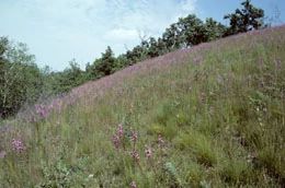
Photo by Ron Kurowski
Stretching across more than 20 miles of kettle moraine topography of kettle holes, interlobate moraine, and outwash plains in southeastern Wisconsin, this preserve consists of multiple sites containing prairie and oak opening communities. Each site has a unique flora which together characterizes the presettlement flora of the region. The prairies are dominated by big and little blue-stems,
Indian grass, prairie drop-seed, and side-oats grama. Flowering plants include pasque flower, bird's foot violet, purple prairie-clover, hoary puccoon, old field goldenrod, and blazing star. The Whitewater Oak Opening, covering 120 acres of rugged morainal topography, is dominated by bur oak on the ridge tops and south- and southwest-facing slopes, by red oak on the north-facing slopes, and by white oak in other places.
Like the few other remnant oak openings in the state, it has been invaded by shrubs and other woody growth over the years, especially honeysuckle and prickly ash. However, a wildfire in the 1950s opened up the site to a certain extent, and this natural fire is being mimicked by prescribed burning, reinstating this crucial process of the oak opening ecosystem. Messinger Dry Prairie and Savanna is owned by the DNR and was designated a State Natural Area in 1990.
Very few State Natural Areas have public facilities, but nearly all are open for a variety of recreational activities as indicated below. Generally, there are no picnic areas, restrooms, or other developments. Parking lots or designated parking areas are noted on individual SNA pages and maps. Trails, if present, are typically undesignated footpaths. If a developed trail is present, it will normally be noted on the SNA map and/or under the "Access" tab. A compass and topographic map or a GPS unit are useful tools for exploring larger, isolated SNAs.
The good majority of SNAs are isolated and have few or no facilities. Some SNAs have vehicle access lanes or parking lots, but their accessibility may vary depending on weather conditions. Parking lots and lanes are not plowed during winter. Hiking trails may be nonexistent or consist of undeveloped footpaths. A GPS unit or compass and a detailed topographic map are useful tools for exploring larger SNAs.
Entrance fees: Excepting Parfrey's Glen, the Cambrian Outlook in the Dells of the Wisconsin River, SNAs within State Parks and some within State Forests, all other DNR-owned SNAs do not have any admission fees.
Allowable activities: DNR-owned land
In general, the activities listed below are allowed on all DNR-owned SNA lands. Exceptions to this list of public uses, such as SNAs closed to hunting, are noted under the "Access" tab above and posted with signs on site.
- Hiking
- Fishing
- Cross country skiing
- Hunting
- Trapping
- Scientific research (permit required [PDF])
- Outdoor education
- Wild edibles (What is this?)
- Pets (Rules)
- Wildlife viewing
Prohibited activities: all SNAs
- Camping and campfires
- Collecting of animals (other than legally harvested species), non-edible fungi, rocks, minerals, fossils, archaeological artifacts, soil, downed wood, or any other natural material, alive or dead.
- Collecting for scientific research requires a permit issued by the DNR
- Collecting of plants including seeds, roots or other non-edible parts of herbaceous plants such as wildflowers or grasses
- Geocaching
- Horseback riding
- Rock climbing
- Vehicles, including bicycles, ATVs, aircraft, and snowmobiles except on trails and roadways designated for their use.
For rules governing state-owned SNAs and other state lands, please consult Chapter NR 45 Wis. Admin. Code [exit DNR].
Location
Within the Southern Unit of the Kettle Moraine State Forest, Jefferson, Walworth and Waukesha County. 254 acres.
Driving directions
The preserve encompasses multiple units. See the maps for more information or contact the State Natural Areas Program for assistance.
The DNR's state natural areas program is comprised of lands owned by the state, private conservation organizations, municipalities, other governmental agencies, educational institutions and private individuals. While the majority of SNAs are open to the public, access may vary according to individual ownership policies. Public use restrictions may apply due to public safety, or to protect endangered or threatened species or unique natural features. Lands may be temporarily closed due to specific management activities.
Users are encouraged to contact the landowner for more specific details. The data shown on these maps have been obtained from various sources, and are of varying age, reliability, and resolution. The data may contain errors or omissions and should not be interpreted as a legal representation of legal ownership boundaries. To create your custom map where you can zoom to a specific location, please use the DNR's Mapping Application.
Clifford Messinger Dry Prairie & Savanna Preserve is owned by: Wisconsin DNR