Brule Rush Lake
No. 401
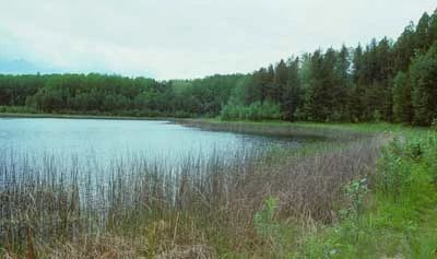
Photo by Thomas A. Meyer/DNR
Brule Rush Lake features a 22-acre soft-water seepage lake with an undisturbed shoreline and a good example of an inland lake beach. The lake is slightly alkaline and has clear water, a sandy bottom, and a maximum depth of 9 feet. Winterkill conditions have not occurred here despite the shallow depth.
The lake experiences significant natural water level fluctuations, which have kept the littoral zone open and allowed colonization by several distinct floristic associations. The inundated zone is composed mostly of spike-rushes and bulrushes. The middle beach, with a substrate of moist sand, supports a diverse array of sedges and rushes, creeping clubmoss, purple gerardia, and several large populations of the insectivorous round-leaved sundew.
The dry upper beach is vegetated with coarser plants such as grass-leaved goldenrod, boneset, Canada bluejoint grass, and red-stemmed gentian. Along the south shore is an area of spring seepages. This site is exemplary for its aquatic invertebrate community, including two rare species.
Many other uncommon aquatic invertebrates have also been documented. Although seepage lakes with naturally fluctuating shorelines are common in this region, the rate of lake and shoreline development has accelerated tremendously in recent years, destroying or damaging many littoral habitats in the process. The surrounding uplands are forested with jack pine, red pine, and aspen. Brule Rush Lake is the first interior beach designated in the State Natural Areas Program and was designated a State Natural Area in 2003. Brule Rush Lake is owned by the DNR.
Very few State Natural Areas have public facilities, but nearly all are open for a variety of recreational activities as indicated below. Generally, there are no picnic areas, restrooms, or other developments. Parking lots or designated parking areas are noted on individual SNA pages and maps. Trails, if present, are typically undesignated footpaths. If a developed trail is present, it will normally be noted on the SNA map under the Maps tab. A compass and topographic map or a GPS unit are useful tools for exploring larger, isolated SNAs.
The good majority of SNAs are isolated and have few or no facilities. Some SNAs have vehicle access lanes or parking lots, but their accessibility may vary depending on weather conditions. Parking lots and lanes are not plowed during winter. Hiking trails may be nonexistent or consist of undeveloped footpaths. A GPS unit or compass and a detailed topographic map are useful tools for exploring larger SNAs.
Entrance fees: Except for Parfrey's Glen, the Cambrian Outlook in the Dells of the Wisconsin River, SNAs within State Parks and some within State Forests, all other DNR-owned SNAs do not have any admission fees. For more information, see Wis. Admin. Code NR 45 [exit DNR]. For non-DNR-owned SNAs, we are unaware of any vehicle or admission fees. However, please contact the landowner for more information.
Allowable activities: DNR-owned land
The activities listed below are generally allowed on all DNR-owned SNA lands. Exceptions to this list of public uses, such as SNAs closed to hunting, are noted above and posted with signs on the property site.
- Hiking
- Fishing
- Cross country skiing
- Hunting
- Trapping
- Scientific research (permit required [PDF])
- Outdoor education
- Wild edibles (What is this?)
- Pets (Rules)
- Wildlife viewing
Prohibited activities: all SNAs
- Camping and campfires
- Collecting of animals (other than legally harvested species), non-edible fungi, rocks, minerals, fossils, archaeological artifacts, soil, downed wood, or any other natural material alive or dead.
- Collecting for scientific research requires a permit issued by the DNR
- Collecting of plants including seeds, roots or other non-edible parts of herbaceous plants such as wildflowers or grasses
- Geocaching
- Horseback riding
- Rock climbing
- Vehicles, including bicycles, ATVs, aircraft, and snowmobiles except on trails and roadways designated for their use.
For rules governing state-owned SNAs and other state lands, please consult Chapter NR 45 Wis. Admin. Code [exit DNR].
Location
Within the Brule River State Forest, Douglas County. T46N-R10W, Sections 1, 12. 22 acres.
Driving directions
From the intersection of Highways 27 and 2 in Brule, go south on 27 for 5.7 miles, then east on Rush Lake Road for 2.2 miles, then south on County Line Road to a parking area east of the road. Or continue on Rush Lake Road anothemiles1 mile to a second parking area south of the road.
The DNR's state natural areas program is comprised of lands owned by the state, private conservation organizations, municipalities, other governmental agencies, educational institutions, and private individuals. While the majority of SNAs are open to the public, access may vary according to individual ownership policies. Public use restrictions may apply due to public safety, or to protect endangered or threatened species or unique natural features. Lands may be temporarily closed due to specific management activities.
Users are encouraged to contact the landowner for more specific details. The data shown on these maps have been obtained from various sources, and are of varying age, reliability, and resolution. The data may contain errors or omissions and should not be interpreted as a legal representation of legal ownership boundaries. To create your custom map where you can zoom to a specific location, please use the DNR's Mapping Application.
Brule Rush Lake is owned by: Wisconsin DNR
Management objectives and prescriptions
Read the Brule River Master Plan [PDF] for details.