Brule Glacial Spillway
No. 161
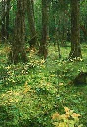
Photo by Thomas A. Meyer/DNR
Following the retreat of the glaciers, Lake Superior drained southwestward through what are now the Bois Brule and St. Croix River valleys. This created the long, narrow, steep-sided and relatively straight valley, which exists today and possesses many unusual ecological attributes. The present Brule River originates from springs within an extensive conifer swamp near Solon Springs and flows north to Lake Superior.
The upper stretches of the river are slow, with many meanders, and receive cold, clean water from numerous springs and seepages. Just above Stone's Bridge the character of the river changes; the gradient begins to grow steeper; the bottom materials include gravel, cobbles and boulders; meanders are much less frequent; and several large spring ponds feed the main stem. This reach of the Brule is very scenic and flows through a conifer swamp of mature white cedar, balsam fir, and spruce with occasional pockets of black ash and alder. The ground layer is rich, with many ferns, mosses and several species of orchids present. The swamp floor is uneven and occupies a seepage slope with a noticeable gradient from the uplands to the river. This seepage slope discouraged the development of logging roads and trails, and the swamp remains in near pre-settlement condition with evidence of only limited logging. This contrasts with areas downstream that were clear-cut and burned.
South of the conifer swamp is a bog surrounded by uplands of sandy pine barrens. The uplands absorb precipitation, which is stored in the organic soils of the bog and seeps into the Brule, producing stable summer flows. Numerous rare plants and animals are found within this diverse area. Nesting birds include olive-sided flycatcher, golden-crowned kinglet, Lincoln's sparrow, saw-whet owl and black-backed woodpecker. The Brule Glacial Spillway is owned by the DNR and was designated a State Natural Area in 2003. It includes two natural areas that were previously designated in 1980 – the Bois-Brule Conifer Bog and Upper Brule River.
Very few State Natural Areas have public facilities, but nearly all are open for a variety of recreational activities as indicated below. Generally, there are no picnic areas, restrooms, or other developments. Parking lots or designated parking areas are noted on individual SNA pages and maps. If a developed trail is present, it will normally be noted on the SNA map and/or under the Maps tab. A compass and topographic map or a GPS unit are useful tools for exploring larger, isolated SNAs.
The good majority of SNAs are isolated and have few or no facilities. Some SNAs have vehicle access lanes or parking lots, but their accessibility may vary depending on weather conditions. Parking lots and lanes are not plowed during winter. Hiking trails may be nonexistent or consist of undeveloped footpaths. A GPS unit or compass and a detailed topographic map are useful tools for exploring larger SNAs.
Entrance fees: Except for Parfrey's Glen, Pewits Nest, Gibraltar Rock, the Dells of the Wisconsin River, SNAs within State Parks and some within State Forests, all other DNR-owned SNAs do not have any admission fees. For more information, see Wis. Admin. Code NR 45.
Allowable activities: DNR-owned land
The activities listed below are generally allowed on all DNR-owned SNA lands. Exceptions to this list of public uses, such as SNAs closed to hunting, are noted above and posted with signs on the property site.
- Hiking
- Fishing
- Cross-country skiing
- Hunting
- Trapping
- Scientific research (permit required)
- Outdoor education
- Wild edibles (What is this?)
- Pets (Rules)
- Wildlife viewing
Prohibited activities: all SNAs
Although a handful of sites allow activities like primitive camping (e.g. Lower Chippewa River on sand bars) or horseback riding (e.g. S. Kettle Moraine), the activities listed below are generally prohibited on DNR-owned SNAs.
- Camping and campfires
- Collecting of animals (other than legally harvested species), non-edible fungi, rocks, minerals, fossils, archaeological artifacts, soil, downed wood, or any other natural material, alive or dead.
- Collecting for scientific research requires a permit issued by the DNR
- Collecting of plants including seeds, roots or other non-edible parts of herbaceous plants such as wildflowers or grasses
- Drones: Flying-related activities, including the use of drones, hang-gliders and model airplanes, are prohibited. Permission may be issued by the SNA Program for the use of drones for educational or research purposes
- Geocaching
- Horseback riding
- Rock climbing
- Vehicles, including bicycles, ATVs, aircraft, and snowmobiles except on trails and roadways designated for their use.
For rules governing state-owned SNAs and other state lands, please consult Chapter NR 45 Wis. Admin. Code.
Location
Within the Brule River State Forest, Douglas County. T45N-T11W Sections 3, 4, 8, 9, 17. T46N-R10W, Sections 20, 29, 20. T46N-R11W Sections 2, 35, 36. 2,656 acres.
Driving directions
The area is accessible by land and water.
By water: There are several options for short to long paddling trips on the river. Refer to the Brule River State Forest map for alternatives. For a 4.5-mile paddle through the natural area in the upper reaches of the Brule, put in at the Stone Chimney carry-in canoe launch and take out at the Stones Bridge landing on County Highway S. This route can be extended on the upstream end by putting in at the County Highway P landing, or on the downstream end by taking out at the Winneboujou Landing on County Highway B.
By land: the site is accessible via the North Country Trail (NCT), which runs parallel to the river in the southern portion of the natural area. This is also the historic Portage Trail, an overland route on a major watershed divide that linked the Bois-Brule River flowing north into Lake Superior with the St. Croix River flowing south to the Mississippi. A spur trail off the NCT heads west into the wetland on a wooden boardwalk.
To reach the NCT trailhead: From the junction of Business Highway 53 and County Highway A in Solon Springs, go north and east on A 3.6 miles to the wayside parking area on the west side of the highway. The NCT crosses Highway A near the southern end of the wayside. Take the fork to the left (west) to hike the "Brule Boardwalk" spur trail.
The DNR's state natural areas program is comprised of lands owned by the state, private conservation organizations, municipalities, other governmental agencies, educational institutions, and private individuals. While the majority of SNAs are open to the public, access may vary according to individual ownership policies. Public use restrictions may apply due to public safety, or to protect endangered or threatened species or unique natural features. Lands may be temporarily closed due to specific management activities.
Users are encouraged to contact the landowner for more specific details. The data shown on these maps have been obtained from various sources, and are of varying age, reliability, and resolution. The data may contain errors or omissions and should not be interpreted as a legal representation of legal ownership boundaries. To create your custom map where you can zoom to a specific location, please use the DNR's Mapping Application.
Brule Glacial Spillway is owned by the Wisconsin DNR.