Bluff Creek
No. 271
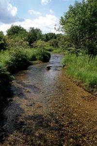
Photo by T. Meyer
Bluff Creek features a series of springs and elevated hard water spring runs and seepage slopes, which originate at the base of a morainal ridge. Also present are high-quality mound fens, wet-mesic prairie and southern sedge meadow communities, southern dry-mesic forest, and stretches of a fast, hard, cold stream. Small tributaries enter Bluff Creek in several places offering distinct habitats for many calcium-loving plants that are unable to withstand the heavy flow in Bluff Creek itself. These small tributaries also contain many sedge species such as slender and fen star sedge.
There are two substantial springs and runs that flow into Bluff Creek. The westernmost is the largest, with mats of the macro-alga Chara and aquatic species such as round-leaved monkey flower and cut-leaved water parsnip. The banks of this run are highly calcareous and contain fen and sedge meadow-wet prairie species. The more easterly spring run is smaller and emanates at nearly the same elevation as the creek; bubbling up through clayey sand that causes the run to appear milky. The large bubbling springs are the largest and least disturbed in this region. Also present is a relatively undisturbed dry-mesic woods dominated by large red oaks with bur and white oaks, black cherry, and shagbark hickory. Herbaceous woodland plants include wild geranium, mayapple, blue cohosh, and jack-in-the-pulpit. Bluff Creek harbors numerous rare plants and animals. Bluff Creek is owned by the DNR and was designated a State Natural Area in 1993.
Very few State Natural Areas have public facilities, but nearly all are open for a variety of recreational activities as indicated below. Generally, there are no picnic areas, restrooms, or other developments. Parking lots or designated parking areas are noted on individual SNA pages and maps. Trails, if present, are typically undesignated footpaths. If a developed trail is present, it will normally be noted on the SNA map under the Maps tab. A compass and topographic map or a GPS unit are useful tools for exploring larger, isolated SNAs.
The good majority of SNAs are isolated and have few or no facilities. Some SNAs have vehicle access lanes or parking lots, but their accessibility may vary depending on weather conditions. Parking lots and lanes are not plowed during winter. Hiking trails may be nonexistent or consist of undeveloped footpaths. A GPS unit or compass and a detailed topographic map are useful tools for exploring larger SNAs.
Entrance fees: Except for Parfrey's Glen, the Cambrian Outlook in the Dells of the Wisconsin River, SNAs within State Parks and some within State Forests, all other DNR-owned SNAs do not have any admission fees. For more information, see Wis. Admin. Code NR 45. For non-DNR-owned SNAs, we are unaware of any vehicle or admission fees. However, please contact the landowner for more information.
Allowable activities: DNR-owned land
The activities listed below are generally allowed on all DNR-owned SNA lands. Exceptions to this list of public uses, such as SNAs closed to hunting, are noted above and posted with signs on the property site.
- Hiking
- Fishing
- Cross country skiing
- Hunting
- Trapping
- Scientific research (permit required)
- Outdoor education
- Wild edibles (What is this?)
- Pets (Rules)
- Wildlife viewing
Prohibited activities: all SNAs
- Camping and campfires
- Collecting of animals (other than legally harvested species), non-edible fungi, rocks, minerals, fossils, archaeological artifacts, soil, downed wood, or any other natural material alive or dead.
- Collecting for scientific research requires a permit issued by the DNR
- Collecting of plants including seeds, roots or other non-edible parts of herbaceous plants such as wildflowers or grasses
- Geocaching
- Horseback riding
- Rock climbing
- Vehicles, including bicycles, ATVs, aircraft, and snowmobiles except on trails and roadways designated for their use.
For rules governing state-owned SNAs and other state lands, please consult Chapter NR 45 Wis. Admin. Code [exit DNR].
Location
Within the Southern Unit of the Kettle Moraine State Forest, Walworth County. T4N-R16E, Section 19. T4N-R15E, Sections 14, 23, 24. 296 acres.
Driving directions
From the junction of U.S. Highway 12 and County Highway P about 0.5 miles east of Whitewater, go south on P about 2.1 miles to the Bluff Creek bridge crossing and a parking area west of the road.
The DNR's state natural areas program is comprised of lands owned by the state, private conservation organizations, municipalities, other governmental agencies, educational institutions, and private individuals. While the majority of SNAs are open to the public, access may vary according to individual ownership policies. Public use restrictions may apply due to public safety, or to protect endangered or threatened species or unique natural features. Lands may be temporarily closed due to specific management activities.
Users are encouraged to contact the landowner for more specific details. The data shown on these maps have been obtained from various sources, and are of varying age, reliability, and resolution. The data may contain errors or omissions and should not be interpreted as a legal representation of legal ownership boundaries. To create your custom map where you can zoom to a specific location, please use the DNR's Mapping Application.
Bluff Creek is owned by: Wisconsin DNR