Bloch Oxbow
No. 234
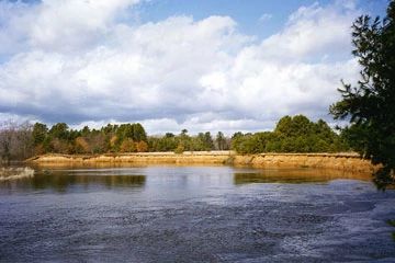
Photo by William Bloch
Bloch Oxbow lies on a level sandy upland a few feet above the floodplain of the Peshtigo River, 2 miles upstream of its confluence with Green Bay. It protects one of the best remaining examples of northern dry-mesic forest - a type that was formerly widespread in northeastern Wisconsin but is now reduced to small, often degraded remnants. Canopy dominants are red oak and red maple with super canopy white pine to 36 inches d.b.h. Characteristic shrubs include hazelnut, witch hazel, huckleberry, blueberry and withered an uncommon shrub species.
Prevalent herbaceous plants are bracken fern, interrupted fern, Canada mayflower, wild sarsaparilla, and large-leaved aster. Bordering the Peshtigo River is a floodplain forest at the extreme northeastern edge of its range in Wisconsin. Dominants include silver maple with green ash, elm, basswood, bitternut hickory, cottonwood, and black willow. Shrubs, emergent aquatic, and wet meadow vegetation, including sedges, rushes, and bluejoint grass, dominate the adjacent wetlands. Pockets of more mesic forest with hemlock and American beech are found in the southern portion of the site, while in the north is a xeric woodland dominated by Hill's, red, and white oaks, bigtooth aspen, and white, red, and jack pines.
The ground layer is primarily bracken fern with ericaceous species and Pennsylvania sedge. Widely scattered, very old, charred stumps are evident in the area and may remain from the historic Peshtigo fire of 1871. The natural area is critical habitat for several sensitive bird species. A great blue heron rookery and a large colony of bank swallows are also found here. Bloch Oxbow is owned by the DNR and was designated a State Natural Area in 1990.
Very few State Natural Areas have public facilities, but nearly all are open for a variety of recreational activities as indicated below. Generally, there are no picnic areas, restrooms, or other developments. Parking lots or designated parking areas are noted on individual SNA pages and maps. Trails, if present, are typically undesignated footpaths. If a developed trail is present, it will normally be noted on the SNA map under the Maps tab. A compass and topographic map or a GPS unit are useful tools for exploring larger, isolated SNAs.
The good majority of SNAs are isolated and have few or no facilities. Some SNAs have vehicle access lanes or parking lots, but their accessibility may vary depending on weather conditions. Parking lots and lanes are not plowed during winter. Hiking trails may be nonexistent or consist of undeveloped footpaths. A GPS unit or compass and a detailed topographic map are useful tools for exploring larger SNAs.
Entrance fees: Except for Parfrey's Glen, the Cambrian Outlook in the Dells of the Wisconsin River, SNAs within State Parks and some within State Forests, all other DNR-owned SNAs do not have any admission fees. For more information, see Wis. Admin. Code NR 45. For non-DNR-owned SNAs, we are unaware of any vehicle or admission fees. However, please contact the landowner for more information.
Allowable activities: DNR-owned land
The activities listed below are generally allowed on all DNR-owned SNA lands. Exceptions to this list of public uses, such as SNAs closed to hunting, are noted above and posted with signs on the property site.
- Hiking
- Fishing
- Cross country skiing
- Hunting
- Trapping
- Scientific research (permit required [PDF])
- Outdoor education
- Wild edibles (What is this?)
- Pets (Rules)
- Wildlife viewing
Prohibited activities: all SNAs
- Camping and campfires
- Collecting of animals (other than legally harvested species), non-edible fungi, rocks, minerals, fossils, archaeological artifacts, soil, downed wood, or any other natural material alive or dead.
- Collecting for scientific research requires a permit issued by the DNR
- Collecting of plants including seeds, roots or other non-edible parts of herbaceous plants such as wildflowers or grasses
- Geocaching
- Horseback riding
- Rock climbing
- Vehicles, including bicycles, ATVs, aircraft, and snowmobiles except on trails and roadways designated for their use.
For rules governing state-owned SNAs and other state lands, please consult Chapter NR 45 Wis. Admin. Code [exit DNR].
Location
Marinette County. T29N-R23E, Sections 3, 4, 9, 10. 610 acres.
Driving directions
From the junction of U.S. Highway 41 and County Highway B in Peshtigo, go south on B for 1.3 miles, then south on County Highway BB for 2.8 miles to a parking area east side of the road. The best pines are east of BB.
The DNR's state natural areas program is comprised of lands owned by the state, private conservation organizations, municipalities, other governmental agencies, educational institutions, and private individuals. While the majority of SNAs are open to the public, access may vary according to individual ownership policies. Public use restrictions may apply due to public safety, or to protect endangered or threatened species or unique natural features. Lands may be temporarily closed due to specific management activities.
Users are encouraged to contact the landowner for more specific details. The data shown on these maps have been obtained from various sources, and are of varying age, reliability, and resolution. The data may contain errors or omissions and should not be interpreted as a legal representation of legal ownership boundaries. To create your custom map where you can zoom to a specific location, please use the DNR's Mapping Application.
Bloch Oxbow is owned by: Wisconsin DNR
Management objectives and prescriptions
Read the Green Bay Planning Group Master Plan [PDF] for details.