Bear Creek Hemlocks
No. 463
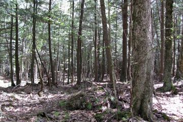
Photo by U.S. Forest Service
Bear Creek Hemlocks encompasses a range of forest types, topography, and moisture regimes. The hemlock forest and associated sedge-blue-joint grass meadows, alder thickets, and hardwood swamps separate an area of recessional moraine on the west from the ground moraine to the east. A soft water drainage stream, Bear Creek is part of the Yellow River watershed and a two-mile stretch meanders through the area in a southerly direction, draining both ash and spruce swamps. Of primary importance at this site are two old-growth stands of hemlock-dominated forest near Bear Creek. Structurally, both stands contain several well-developed old growth attributes, including the presence of very large diameter (30-41") super-canopy white pine.
The first stand, which borders an extensive wet meadow/alder bottoms on Bear Creek, has a relatively simple species composition typical of a lowland (TMC) type of hemlock forest found throughout the ground moraine. However, the second stand, which is adjacent to a small ice-walled lake plain associated with an area of the recessional moraine, has an unusually rich species composition. Super canopy white pine, up to 41 inches in diameter, tower over a mixed forest of hemlock, yellow birch, sugar maple, white ash, and basswood. Snags, coarse woody debris, and tip-up mounds are common. Ground flora vegetation is especially noteworthy, with a high abundance of most of the rich site indicators in addition to those species more typical of upland hemlock-hardwood forests.
Species include Virginia water-leaf, bloodroot, cut-leaved toothwort, and woodland phlox. Spring ephemerals are common. This occurrence grades down into an equally diverse mixed black ash-white cedar swamp, which has high numbers of several relatively uncommon orchid species including moccasin flower, and lesser purple fringed orchid. Associated tree species include red maple, yellow birch, and balsam fir. The eastern half of the site is ground moraine supporting a hemlock-hardwood forest on the level to gently rolling topography. Bordering the lowlands along Bear Creek is a high-quality hemlock-dominated stand with numerous surface boulders and a developing old-growth structure. Super-canopy white pine is frequent. Much of the ground moraine is level and damp.
Hemlock and yellow birch are common with associated sugar maple, and red maple in lower areas. Groundlayer species include three-leaved goldthread, bunchberry, mountain wood sorrel, and Canada mayflower. Hazel brush is common in places. Large, older snags and trees within the uplands provide nesting sites for pileated woodpeckers and flying squirrels. Bear Creek Hemlocks is owned by the U.S. Forest Service and was designated a State Natural Area in 2007. This site is also recognized by the Forest Service as an established Research Natural Area.
Very few State Natural Areas have public facilities, but nearly all are open for a variety of recreational activities as indicated below. Generally, there are no picnic areas, restrooms, or other developments. Parking lots or designated parking areas are noted on individual SNA pages and maps. Trails, if present, are typically undesignated footpaths. If a developed trail is present, it will normally be noted on the SNA map and/or under the "Access" tab. A compass and topographic map or a GPS unit are useful tools for exploring larger, isolated SNAs.
The good majority of SNAs are isolated and have few or no facilities. Some SNAs have vehicle access lanes or parking lots, but their accessibility may vary depending on weather conditions. Parking lots and lanes are not plowed during winter. Hiking trails may be nonexistent or consist of undeveloped footpaths. A GPS unit or compass and a detailed topographic map are useful tools for exploring larger SNAs.
Non-DNR lands
Entrance fees: For non-DNR-owned SNAs, we are unaware of any vehicle or admission fees. However, please contact the landowner for more information.
Hunting and trapping
Other activities
Other allowable activities such as - but not limited to camping, geocaching and bicycling are determined by the landowner. Please contact them directly or visit their websites for details.
Location
Within the Chequamegon-Nicolet National Forest. Taylor County. T32N-3W, Sections 1, 2, 3. T33N-R3W, Sections 34, 35, 36. 967 acres.
Driving directions
From the intersection of Hwy 73 and Konsella Road (FS 577) go east approximately 3 miles to a gated gravel pit on the north side of the road. Park here and walk north approximately 1 mile into the site.
The DNR's state natural areas program is comprised of lands owned by the state, private conservation organizations, municipalities, other governmental agencies, educational institutions, and private individuals. While the majority of SNAs are open to the public, access may vary according to individual ownership policies. Public use restrictions may apply due to public safety, or to protect endangered or threatened species or unique natural features. Lands may be temporarily closed due to specific management activities.
Users are encouraged to contact the landowner for more specific details. The data shown on these maps have been obtained from various sources, and are of varying age, reliability, and resolution. The data may contain errors or omissions and should not be interpreted as a legal representation of legal ownership boundaries. To create your custom map where you can zoom to a specific location, please use the DNR's Mapping Application.
Bear Lake Slough is owned by: The US Forest Service