Bear Beach
No. 402
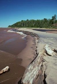
Photo by Thomas A. Meyer/DNR
Bear Beach features several extensive stretches of undeveloped beach along the Lake Superior shore, west of the Brule River mouth. The beaches are composed mostly of sand and are unvegetated due to their exposure to wave and ice action. Locally, there are small, scattered pockets of cobblestones and driftwood "gardens". The site includes the slump clay banks that contain uncommonly occurring combinations of plants and animals.
Since the clay banks are continually eroding as they have for thousands of years, this site will continue to move and change with time. The uplands above the beach and adjacent to the natural area are vegetated with speckled alder and a rather open "forest" of trembling aspen, scattered white spruce, white pine, and balsam fir. Paper birch is locally dominant, especially on the bluffs bordering the lower reaches of tributary streams that flow directly into Lake Superior. Several of these streams terminate in small estuarine lagoons at the lake.
During migration periods this area is used for foraging and resting by terns, shorebirds, gulls, snow buntings, and water pipits – sometimes in substantial numbers. Bear sign was common on the beach and in the adjacent thickets. As development pressures on shoreline habitats are increasing in northern Wisconsin, Bear Beach represents a rare opportunity to protect beach and clay banks on over five miles of undeveloped, unobstructed Lake Superior shore. Bear Beach is owned by the DNR and was designated a State Natural Area in 2003.
Very few State Natural Areas have public facilities, but nearly all are open for a variety of recreational activities as indicated below. Generally, there are no picnic areas, restrooms, or other developments. Parking lots or designated parking areas are noted on individual SNA pages and maps. Trails, if present, are typically undesignated footpaths. If a developed trail is present, it will normally be noted on the SNA map under the Maps tab. A compass and topographic map or a GPS unit are useful tools for exploring larger, isolated SNAs.
The good majority of SNAs are isolated and have few or no facilities. Some SNAs have vehicle access lanes or parking lots, but their accessibility may vary depending on weather conditions. Parking lots and lanes are not plowed during winter. Hiking trails may be nonexistent or consist of undeveloped footpaths. A GPS unit or compass and a detailed topographic map are useful tools for exploring larger SNAs.
Entrance fees: Excepting Parfrey's Glen, the Cambrian Outlook in the Dells of the Wisconsin River, SNAs within State Parks and some within State Forests, all other DNR-owned SNAs do not have any admission fees.
Allowable activities: DNR-owned land
The activities listed below are generally allowed on all DNR-owned SNA lands. Exceptions to this list of public uses, such as SNAs closed to hunting, are noted above and posted with signs on the property site.
- Hiking
- Fishing
- Cross country skiing
- Hunting
- Trapping
- Scientific research (permit required)
- Outdoor education
- Wild edibles (What is this?)
- Pets (Rules)
- Wildlife viewing
Prohibited activities: all SNAs
- Camping and campfires
- Collecting of animals (other than legally harvested species), non-edible fungi, rocks, minerals, fossils, archaeological artifacts, soil, downed wood, or any other natural material alive or dead.
- Collecting for scientific research requires a permit issued by the DNR
- Collecting of plants including seeds, roots or other non-edible parts of herbaceous plants such as wildflowers or grasses
- Geocaching
- Horseback riding
- Rock climbing
- Vehicles, including bicycles, ATVs, aircraft, and snowmobiles except on trails and roadways designated for their use.
For rules governing state-owned SNAs and other state lands, please consult Chapter NR 45 Wis. Admin. Code [exit DNR].
Location
Within the Brule River State Forest, Douglas County. T49N-R10W, Sections 8, 9, 17, 18. T49N-R11W Sections 13, 14, 22, 23. 97 acres.
Driving directions
By canoe. Canoe downstream to Lake Superior. On foot, from the intersection of Highways 2 and H in Brule, go north on H for 11 miles, then west and north for 3.8 miles on Brule River Road to a parking lot. The natural area includes the 5-mile stretch west of the Brule River.
The DNR's state natural areas program is comprised of lands owned by the state, private conservation organizations, municipalities, other governmental agencies, educational institutions, and private individuals. While the majority of SNAs are open to the public, access may vary according to individual ownership policies. Public use restrictions may apply due to public safety, or to protect endangered or threatened species or unique natural features. Lands may be temporarily closed due to specific management activities.
Users are encouraged to contact the landowner for more specific details. The data shown on these maps have been obtained from various sources, and are of varying age, reliability, and resolution. The data may contain errors or omissions and should not be interpreted as a legal representation of legal ownership boundaries. To create your custom map where you can zoom to a specific location, please use the DNR's Mapping Application.
Bear Beach is owned by the Wisconsin DNR