Bean Lake
No. 111
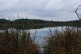
Photo by Josh Mayer
Bean Lake is a 33-acre alkaline seepage lake surrounded by tamarack and shrub swamps. The maximum depth is 6 feet, and the bottom substrate is poorly decomposed brown and black peat. The water is usually turbid and supports algal blooms; yellow pond lily is the most common macrophyte.
Surrounding the lake is a narrow zone of swamp loosestrife with cat-tails, sedges, and soft stem bulrush on the northeast edge. Tamarack and shrub-carr of dogwood, bog birch, poison sumac, and willows surround the lake and encompass the entire area to the edge of Rock Lake. Along the northeast edge of the lake are two small upland islands forested with deciduous hardwoods. Within the swamp surrounding the lake there are few characteristic bog species. Bird species nesting within the natural area include green-backed herons, wood ducks, mallards, blue-winged teal, sandhill crane, great horned owl, and long-eared owl. Bean Lake is owned by the DNR and was designated a State Natural Area in 1973.
Very few State Natural Areas have public facilities, but nearly all are open for a variety of recreational activities as indicated below. Generally, there are no picnic areas, restrooms, or other developments. Parking lots or designated parking areas are noted on individual SNA pages and maps. Trails, if present, are typically undesignated footpaths. If a developed trail is present, it will normally be noted on the SNA map under the Maps tab. A compass and topographic map or a GPS unit are useful tools for exploring larger, isolated SNAs.
The good majority of SNAs are isolated and have few or no facilities. Some SNAs have vehicle access lanes or parking lots, but their accessibility may vary depending on weather conditions. Parking lots and lanes are not plowed during winter. Hiking trails may be nonexistent or consist of undeveloped footpaths. A GPS unit or compass and a detailed topographic map are useful tools for exploring larger SNAs.
Entrance fees: Except for Parfrey's Glen, the Cambrian Outlook in the Dells of the Wisconsin River, SNAs within State Parks and some within State Forests, all other DNR-owned SNAs do not have any admission fees. For more information, see Wis. Admin. Code NR 45. For non-DNR-owned SNAs, we are unaware of any vehicle or admission fees. However, please contact the landowner for more information.
Allowable activities: DNR-owned land
The activities listed below are generally allowed on all DNR-owned SNA lands. Exceptions to this list of public uses, such as SNAs closed to hunting, are noted above and posted with signs on the property site.
- Hiking
- Fishing
- Cross country skiing
- Hunting
- Trapping
- Scientific research (permit required)
- Outdoor education
- Wild edibles (What is this?)
- Pets (Rules)
- Wildlife viewing
Prohibited activities: all SNAs
- Camping and campfires
- Collecting of animals (other than legally harvested species), non-edible fungi, rocks, minerals, fossils, archaeological artifacts, soil, downed wood, or any other natural material, alive or dead.
- Collecting for scientific research requires a permit issued by the DNR
- Collecting of plants including seeds, roots or other non-edible parts of herbaceous plants such as wildflowers or grasses
- Geocaching
- Horseback riding
- Rock climbing
- Vehicles, including bicycles, ATVs, aircraft, and snowmobiles except on trails and roadways designated for their use.
For rules governing state-owned SNAs and other state lands, please consult Chapter NR 45 Wis. Admin. Code [exit DNR].
Location
Within Lake Mills Wildlife Area, Jefferson County. T7N-R13E, Section 22. 198 acres.
Driving directions
From the intersection of County Highways B and S west of Lake Mills, proceed south on S, 2.3 miles, then east on Bean Lake Road to a parking lot at the southwest corner of the site. Walk north on the old road and trail, which leads to the lake.
The DNR's state natural areas program is comprised of lands owned by the state, private conservation organizations, municipalities, other governmental agencies, educational institutions and private individuals. While the majority of SNAs are open to the public, access may vary according to individual ownership policies. Public use restrictions may apply due to public safety, or to protect endangered or threatened species or unique natural features. Lands may be temporarily closed due to specific management activities.
Users are encouraged to contact the landowner for more specific details. The data shown on these maps have been obtained from various sources, and are of varying age, reliability, and resolution. The data may contain errors or omissions and should not be interpreted as a legal representation of legal ownership boundaries. To create your custom map where you can zoom to a specific location, please use the DNR's Mapping Application.
Bean Lake is owned by: Wisconsin DNR