Bayshore Blufflands
No. 377
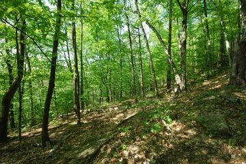
Photo by Thomas A. Meyer/DNR
Located along more than three miles of the Niagara Escarpment, Bayshore Blufflands is an ecologically complex site with a diversity of plant communities both above and below the escarpment and a series of seeps and springs at the base of the bluff's talus slopes. Rising 150-200 feet above the low terrace of Green Bay, the steep carbonate cliffs and outcrops support numerous rare land snails including a state-threatened species. Aspen, sugar maple, red oak, hemlock, and white cedar grow out of the talus affording complete shade to the escarpment maintaining the cool and damp conditions, which support the lush growth of mosses.
The unique site conditions also support such uncommon species as climbing fumitory, mountain maple, bullet fern, common polypody, and fragile fern. Above the escarpment is a dry-mesic forest of red and white pine with red oak. The ground layer is densely dominated by round-leaved dogwood with northern bush honeysuckle, zig-zag goldenrod, big-leaved aster, and bracken fern. The site slowly grades into a richer, more mesic forest containing sugar maple, beech, and red oak with hemlock, and white pine.
Also present is a wet-mesic forest of white cedar, big-tooth aspen, and black ash. Several white cedars reach impressive sizes here. Below the escarpment are seasonally flooded forests dominated by silver maple, and green ash with swamp white oak, American bladdernut, and great water leaf. The site contains many rare plants, including a federally threatened species. Bayshore Blufflands is owned by The Door County Land Trust and The Nature Conservancy and was designated a State Natural Area in 2002.
Very few State Natural Areas have public facilities, but nearly all are open for a variety of recreational activities as indicated below. Generally, there are no picnic areas, restrooms, or other developments. Parking lots or designated parking areas are noted on individual SNA pages and maps. Trails, if present, are typically undesignated footpaths. If a developed trail is present, it will normally be noted on the SNA map located under the Map tab. A compass and topographic map or a GPS unit are useful tools for exploring larger, isolated SNAs.
The good majority of SNAs are isolated and have few or no facilities. Some SNAs have vehicle access lanes or parking lots, but their accessibility may vary depending on weather conditions. Parking lots and lanes are not plowed during winter. Hiking trails may be nonexistent or consist of undeveloped footpaths. A GPS unit or compass and a detailed topographic map are useful tools for exploring larger SNAs.
Non-DNR lands
Entrance fees: For non-DNR-owned SNAs, we are unaware of any vehicle or admission fees. However, please contact the landowner for more information.
Hunting and trapping
This SNA has multiple landowners: Opportunities for hunting and trapping depend on the landowner. In general, most DNR-owned land allows hunting and trapping. Partner-owned land may have other rules (for example, university-owned lands do not allow hunting or trapping). Please contact them directly to find out about their rules for hunting and trapping. You can find a link to other owner websites under the Resources tab.
For hunting opportunities, visit the Door County Land Trust [exit DNR].
Other Activities
Other allowable activities such as - but not limited to camping, geocaching and bicycling are determined by the landowner. Please contact them directly or visit their websites for details.
Location
Door County. Parts of T28N-R26E, Section 6. T29N-R26E, Sections 10, 16, 20, 21, 29, 31, 32. 150 acres.
Driving directions
Located near the shores of Green Bay approximately 2 miles west of Carlsville and 8 miles north of Sturgeon Bay. To access the upper trailhead, from the intersection of Highways 42 and 57 just north of Sturgeon Bay, go north on 42 for 4.5 miles, then west on W. Town Line Road for 1.5 miles, then north on Reynolds Road for 0.5 miles to a small parking area and Door County Land Trust kiosk west of the road. To access the lower trailhead, continue north on Reynolds Road 0.7 miles, then south on County B 0.9 miles to a parking area and trailhead east of the road. Trails provide access into and through the site.
The DNR's state natural areas program is comprised of lands owned by the state, private conservation organizations, municipalities, other governmental agencies, educational institutions and private individuals. While the majority of SNAs are open to the public, access may vary according to individual ownership policies. Public use restrictions may apply due to public safety, or to protect endangered or threatened species or unique natural features. Lands may be temporarily closed due to specific management activities.
Users are encouraged to contact the landowner for more specific details. The data shown on these maps have been obtained from various sources, and are of varying age, reliability, and resolution. The data may contain errors or omissions and should not be interpreted as a legal representation of legal ownership boundaries. To create your custom map where you can zoom to a specific location, please use the DNR's Mapping Application
Bayshore Blufflands is owned by:
- Door County Land Trust