Baxter's Hollow
No. 82
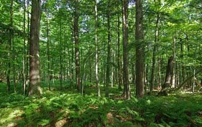
Photo by WI Explorer
Baxter's Hollow features a scenic gorge cut through Baraboo quartzite by Otter Creek, a fast, clear, nearly undisturbed stream flowing over the large quartzite boulders. Although it supports trout, Otter Creek is better known for its diverse and unique aquatic insect fauna including at least 78 species of caddisfly. Cold air drainage has permitted a white pine-dominated forest to persist near the stream.
Understory species on the boulder-strewn slopes are large-leaved aster, marginal wood fern, partridgeberry, sweet cicely, witch hazel, and American cancer root. Most of the site, though, contains a significant portion of the Big Woods, the largest intact contiguous southern dry-mesic forest in Wisconsin with red and white oak, hickory, and basswood. In spring, the forest floor is blanketed with a wide variety of colorful flowers including spring beauty, Jacob's-ladder, trillium, hepatica, shooting-star, dog-tooth violet, and marsh marigold.
The large expanse of woods provides critical habitat for many rare bird species that require large forested tracts. The combined effects of microclimate and different communities have allowed a wide diversity of species to flourish here, including 39 mammals and 92 breeding birds. Baxter's Hollow is owned by The Nature Conservancy and was designated a State Natural Area in 1970.
Very few State Natural Areas have public facilities, but nearly all are open for a variety of recreational activities as indicated below. Generally, there are no picnic areas, restrooms, or other developments. Parking lots or designated parking areas are noted on individual SNA pages and maps. Trails, if present, are typically undesignated footpaths. If a developed trail is present, it will normally be noted on the SNA map located under the Map tab. A compass and topographic map or a GPS unit are useful tools for exploring larger, isolated SNAs.
The good majority of SNAs are isolated and have few or no facilities. Some SNAs have vehicle access lanes or parking lots, but their accessibility may vary depending on weather conditions. Parking lots and lanes are not plowed during winter. Hiking trails may be nonexistent or consist of undeveloped footpaths. A GPS unit or compass and a detailed topographic map are useful tools for exploring larger SNAs.
Non-DNR lands
Entrance fees: For non-DNR-owned SNAs, we are unaware of any vehicle or admission fees. However, please contact the landowner for more information.
Hunting and trapping
This is a non-DNR owned SNA: Opportunities for hunting and trapping depend on the landowner. In general, most DNR-owned land allows hunting and trapping. Partner-owned land may have other rules (for example, university-owned lands do not allow hunting or trapping). Please contact them directly to find out about their rules for hunting and trapping. You can find a link to other owner websites under the Resources tab.
For available hunting opportunities, visit The Nature Conservancy's website: The Nature Conservancy [exit DNR].
Other activities
Other allowable activities such as - but not limited to camping, geocaching and bicycling are determined by the landowner. Please contact them directly or visit their websites for details.
Location
Sauk County. T10N-R5E, Sections 1, 2. T10N-R6E, Sections 4, 5. T11-5E, Sections 35, 36. T11N-R6E, Sections 17, 19, 20, 21, 27, 28, 29, 31, 32, 33. 5,914 acres.
Driving directions
From the intersection of U.S. Highway 12 and State Highway 78 in Sauk City, go west on Highway 12 7.6 miles, then west on County Highway C 1.4 miles, then north on Stones Pocket Road 2+ miles to one of the parking areas along the road. Access also from the north via Forest Drive.
The DNR's state natural areas program is comprised of lands owned by the state, private conservation organizations, municipalities, other governmental agencies, educational institutions and private individuals. While the majority of SNAs are open to the public, access may vary according to individual ownership policies. Public use restrictions may apply due to public safety, or to protect endangered or threatened species or unique natural features. Lands may be temporarily closed due to specific management activities.
Users are encouraged to contact the landowner for more specific details. The data shown on these maps have been obtained from various sources, and are of varying age, reliability, and resolution. The data may contain errors or omissions and should not be interpreted as a legal representation of legal ownership boundaries. To create your custom map where you can zoom to a specific location, please use the DNR's Mapping Application
Baxter's Hollow is owned by:
- The Nature Conservancy