Baraboo River Floodplain Forest
No. 212
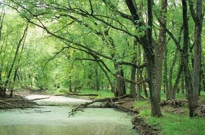
Photo by Thomas A. Meyer/DNR
The Baraboo River Floodplain Forest is a relatively undisturbed lowland forest that lies on nearly level terrain. Occasional sloughs are formed by the gradual filling of old stream meanders (oxbows). Large-diameter trees dominate the forest--silver maple (to 30 inches diameter), hackberry, basswood (to 36 inches diameter), green ash, white ash, American elm, and cottonwood (to 60 inches diameter). The understory is quite open with only a few shrubs and saplings.
The ground layer contains more than fifty species of green dragon, swamp milkweed, Virginia water-leaf, cardinal flower, wood nettle, sensitive fern, greenbriar, poison ivy, and several sedges. This area is an important breeding site for many waterfowl species. The property was originally purchased by The Nature Conservancy and later donated to the U.S. Fish and Wildlife Service as part of the Baraboo River Waterfowl Production Area. The site was designated a State Natural Area in 1988.
Very few State Natural Areas have public facilities, but nearly all are open for a variety of recreational activities as indicated below. Generally, there are no picnic areas, restrooms, or other developments. Parking lots or designated parking areas are noted on individual SNA pages and maps. Trails, if present, are typically undesignated footpaths. If a developed trail is present, it will normally be noted on the SNA map located under the Map tab. A compass and topographic map or a GPS unit are useful tools for exploring larger, isolated SNAs.
The good majority of SNAs are isolated and have few or no facilities. Some SNAs have vehicle access lanes or parking lots, but their accessibility may vary depending on weather conditions. Parking lots and lanes are not plowed during winter. Hiking trails may be nonexistent or consist of undeveloped footpaths. A GPS unit or compass and a detailed topographic map are useful tools for exploring larger SNAs.
Non-DNR lands
Entrance fees: For non-DNR-owned SNAs, we are unaware of any vehicle or admission fees. However, please contact the landowner for more information.
Hunting and trapping
Other activities
Other allowable activities such as - but not limited to camping, geocaching and bicycling are determined by the landowner. Please contact them directly or visit their websites for details.
Location
Columbia County. T12N-R8E, Section 24, SE¼NE¼, NE¼SE¼. 23 acres.
Driving directions
From the intersection of Highways 33 and 78, west of Portage, go east on Highway 33 about 0.2 miles to County Highway U. Then go south on U 1.75 miles to the Baraboo River. Canoe upstream 0.5 miles to the site, just west of Highway 78. Access is also available from the Fish and Wildlife Service parking area on Cascade Mountain Road.
The DNR's state natural areas program is comprised of lands owned by the state, private conservation organizations, municipalities, other governmental agencies, educational institutions and private individuals. While the majority of SNAs are open to the public, access may vary according to individual ownership policies. Public use restrictions may apply due to public safety, or to protect endangered or threatened species or unique natural features. Lands may be temporarily closed due to specific management activities.
Users are encouraged to contact the landowner for more specific details. The data shown on these maps have been obtained from various sources, and are of varying age, reliability, and resolution. The data may contain errors or omissions and should not be interpreted as a legal representation of legal ownership boundaries. To create your custom map where you can zoom to a specific location, please use the DNR's Mapping Application.
Baraboo River Floodplain Forest is owned by the U.S. Fish & Wildlife Service
Southern Wisconsin Bird Alliance (formerly Madison Audubon)