Apple River Canyon
No. 145
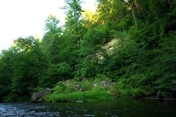
Photo by Josh Mayer
Apple River Canyon features a deep (100-140 feet), narrow (150 feet) gorge along the Apple River about two miles upstream from its confluence with the St. Croix River. The Apple River is a shallow stream flanked by steep high cliffs on both sides. The canyon lies a few miles south of the limits of Glacial Lake Grantsburg, and presumably the gorge was formed during the period of drainage of the lake.
A cross-section of the gorge reveals - from top to bottom - thin layers of glacial outwash and Oneota dolomite (Ordovician), a massive layer of Jordan sandstone (Cambrian), Lodi shale (Cambrian), Nicollet Creek dolomite (Cambrian), and Franconia sandstone (Cambrian). The vegetation is quite interesting due to the nearly east-west orientation of a segment of the gorge, creating north and south walls with contrasting sunlight, moisture, and temperature conditions.
On the upland to the north is an oak forest: on the south-facing upper slope a strip of prairie grasses; on the south-facing cliffs a few lichens and mosses; on the lowest talus slope a floodplain forest; on the north-facing talus a northern dry-mesic forest; on northern cliffs, cryptogams; and the upper slope a narrow prairie. Apple River Canyon is owned by the DNR and was designated a State Natural Area in 1978.
Very few State Natural Areas have public facilities, but nearly all are open for a variety of recreational activities as indicated below. Generally, there are no picnic areas, restrooms, or other developments. Parking lots or designated parking areas are noted on individual SNA pages and maps. Trails, if present, are typically undesignated footpaths. If a developed trail is present, it will normally be noted on the SNA map and/or under the "Access" tab. A compass and topographic map or a GPS unit are useful tools for exploring larger, isolated SNAs.
The good majority of SNAs are isolated and have few or no facilities. Some SNAs have vehicle access lanes or parking lots, but their accessibility may vary depending on weather conditions. Parking lots and lanes are not plowed during winter. Hiking trails may be nonexistent or consist of undeveloped footpaths. A GPS unit or compass and a detailed topographic map are useful tools for exploring larger SNAs.
Entrance fees: Excepting Parfrey's Glen, the Cambrian Outlook in the Dells of the Wisconsin River, SNAs within State Parks and some within State Forests, all other DNR-owned SNAs do not have any admission fees.
NOTE: Per state regulations, hunting is allowed on the DNR-owned SNA lands. However, on lands located within the Village of Rock Springs (see map), the discharge of firearms is prohibited within the village limits. See their Village Ordinance Chapter 4 [exit DNR] for details.
ALLOWABLE ACTIVITIES: DNR-OWNED LAND
The activities listed below are generally allowed on all DNR-owned SNA lands. Exceptions to this list of public uses, such as SNAs closed to hunting, are noted above and posted with signs on the property site.
- Hiking
- Fishing
- Cross country skiing
- Hunting
- Trapping
- Scientific research (permit required)
- Outdoor education
- Wild edibles (What is this?)
- Pets (Rules)
- Wildlife viewing
PROHIBITED ACTIVITIES: ALL SNAS
- Camping and campfires
- Collecting of animals (other than legally harvested species), non-edible fungi, rocks, minerals, fossils, archaeological artifacts, soil, downed wood, or any other natural material, alive or dead.
- Collecting for scientific research requires a permit issued by the DNR
- Collecting of plants including seeds, roots or other non-edible parts of herbaceous plants such as wildflowers or grasses
- Geocaching
- Horseback riding
- Rock climbing
- Vehicles, including bicycles, ATVs, aircraft, and snowmobiles except on trails and roadways designated for their use.
For rules governing state-owned SNAs and other state lands, please consult Chapter NR 45 Wis. Admin. Code [exit DNR].
Location
St. Croix County. T31N-R19W, Sections 21, 28. 183 acres.
Driving directions
From the intersection of County Highway I and State Highway 64 in Somerset, go west on Highway I for 2.4 miles, then continue west on 192nd Avenue for 0.85 miles, then north on 42nd Street for 0.3 miles. Walk northeast on an access lane into the natural area. Or from its intersection with 192nd Avenue, continue on Highway I for another 1.7 miles, then southwest on 208th Avenue for 0.6 miles. Park along the road and walk south into the site.
The DNR's state natural areas program is comprised of lands owned by the state, private conservation organizations, municipalities, other governmental agencies, educational institutions and private individuals. While the majority of SNAs are open to the public, access may vary according to individual ownership policies. Public use restrictions may apply due to public safety, or to protect endangered or threatened species or unique natural features. Lands may be temporarily closed due to specific management activities.
Users are encouraged to contact the landowner for more specific details. The data shown on these maps have been obtained from various sources, and are of varying age, reliability, and resolution. The data may contain errors or omissions and should not be interpreted as a legal representation of legal ownership boundaries. To create your custom map where you can zoom to a specific location, please use the DNR's Mapping Application.
Apple River Canyon is owned by: Wisconsin DNR