Allequash Lake and Pines
No. 508
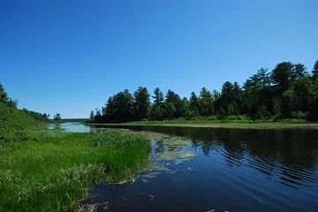
Photo by Joshua Mayer
Situated on gently rolling to rough terrain is a mature second-growth dry-mesic forest surrounding the south basin of Allequash Lake. The forest is dominated by medium to large red oak with white pine, sugar maple, red maple, paper birch and balsam fir. The understory is composed of maple and fir saplings, beaked hazelnut, maple-leaved viburnum, clubmosses and ferns. Other herbaceous ground layer species include Pennsylvania sedge, bunchberry, wild strawberry, Canada mayflower, partridgeberry, gay-wings, elliptic shin-leaf, twisted-stalk, American starflower and false Solomon's-seal. Allequash Lake is a drainage lake with clear, alkaline water. About 60-70% of the south basin is less than five feet deep and supports extensive beds of emergent, floating-leaved, and submerged aquatic plants. Important species include wild rice, large-leaf pondweed, common pondweed, Richardson's pondweed, Robbin's pondweed, flat-stemmed pondweed, northern water-nymph, coon's-tail, common bladderwort, white water-lily, and water-shield. Stands of cat-tail and bulrushes are also present.
Numerous birds make use of the lake and abundant aquatic vegetation including migrating waterfowl, black tern, wood duck, sora, and osprey. Other breeding birds of the area include a broad-winged hawk, belted kingfisher, eastern wood pewee, least flycatcher, winter wren, veery, hermit thrush, Nashville warbler, magnolia warbler, black-throated green warbler, blackburnian warbler, pine warbler, black and white warbler, ovenbird and scarlet tanager. Allequash Lake and Pines is owned by the DNR and was designated a State Natural Area in 2007.
Very few State Natural Areas have public facilities, but nearly all are open for a variety of recreational activities as indicated below. Generally, there are no picnic areas, restrooms, or other developments. Parking lots or designated parking areas are noted on individual SNA pages and maps. Trails, if present, are typically undesignated footpaths. If a developed trail is present, it will normally be noted on the SNA map under the Maps tab. A compass and topographic map or a GPS unit are useful tools for exploring larger, isolated SNAs.
The good majority of SNAs are isolated and have few or no facilities. Some SNAs have vehicle access lanes or parking lots, but their accessibility may vary depending on weather conditions. Parking lots and lanes are not plowed during winter. Hiking trails may be nonexistent or consist of undeveloped footpaths. A GPS unit or compass and a detailed topographic map are useful tools for exploring larger SNAs.
Entrance fees: Excepting Parfrey's Glen, the Cambrian Outlook in the Dells of the Wisconsin River, SNAs within State Parks and some within State Forests, all other DNR-owned SNAs do not have any admission fees.
Allowable activities: DNR-owned land
The activities listed below are generally allowed on all DNR-owned SNA lands. Exceptions to this list of public uses, such as SNAs closed to hunting, are noted above and posted with signs on the property site.
- Hiking
- Fishing
- Cross country skiing
- Hunting
- Trapping
- Scientific research (permit required)
- Outdoor education
- Wild edibles (What is this?)
- Pets (Rules)
- Wildlife viewing
Prohibited activities: all SNAs
- Camping and campfires
- Collecting of animals (other than legally harvested species), non-edible fungi, rocks, minerals, fossils, archaeological artifacts, soil, downed wood, or any other natural material, alive or dead.
- Collecting for scientific research requires a permit issued by the DNR
- Collecting of plants including seeds, roots or other non-edible parts of herbaceous plants such as wildflowers or grasses
- Geocaching
- Horseback riding
- Rock climbing
- Vehicles, including bicycles, ATVs, aircraft, and snowmobiles except on trails and roadways designated for their use.
For rules governing state-owned SNAs and other state lands, please consult Chapter NR 45 Wis. Admin. Code [exit DNR].
Location
Within the Northern Highland-American Legion State Forest, Vilas County. T41N-R7E, Sections 16, 17, 20, 21. 398 acres.
Driving directions
From the intersection of County K and M (Cut-off Road) in Boulder Junction, go south on K for 1.9 miles, then continue south on County M for 3.2 miles, then go east on an access road to the Allequash Lake boat landing and parking. The southern lake basin is electric motors only.
The DNR's state natural areas program is comprised of lands owned by the state, private conservation organizations, municipalities, other governmental agencies, educational institutions and private individuals. While the majority of SNAs are open to the public, access may vary according to individual ownership policies. Public use restrictions may apply due to public safety, or to protect endangered or threatened species or unique natural features. Lands may be temporarily closed due to specific management activities.
Users are encouraged to contact the landowner for more specific details. The data shown on these maps have been obtained from various sources, and are of varying age, reliability, and resolution. The data may contain errors or omissions and should not be interpreted as a legal representation of legal ownership boundaries. To create your custom map where you can zoom to a specific location, please use the DNR's Mapping Application.
Allequash Lake and Pines is owned by: Wisconsin DNR