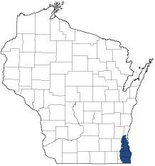
Southern Lake Michigan Coastal
Ecological Landscape
Download the Southern Lake Michigan Coastal chapter [PDF] of the Ecological Landscapes of Wisconsin. This chapter provides a detailed assessment of the ecological and socioeconomic conditions for the Southern Lake Michigan Coastal.
It also identifies important planning and management considerations and suggests management opportunities that are compatible with the ecology of the landscape. The tabs below provide additional information.
Physical And Biotic Environment
Physical And Biotic Environment
Size 843 square miles (539,830 acres). 1.5% of the area of the state. Climate The climate is moderated by Lake Michigan. The mean growing season is 169 days and the mean annual temperature is 47.2deg. F, the longest and warmest of any Ecological Landscape in the state. The mean annual precipitation is 34 inches, the second most precipitation in the state. The mean annual snowfall is 41.9 inches similar to other southern Ecological Landscapes. Lake effect snows occur in areas adjacent to Lake Michigan. The climate (temperature, growing degree days, and precipitation) is suitable for agricultural row crops, small grains, and pastures, which are prevalent land uses in the non-urbanized parts of this Ecological Landscape. Bedrock Predominately Silurian dolomite, generally covered by deposits of glacial drift from 50 to over 100 feet in depth. Geology & Landforms Inland the primary landform is level to gently rolling ground moraine. Near Lake Michigan, landforms include subdued ridge and swale topography, beach and dune complexes, and wave-cut clay bluffs. The river mouths within large cities have all been heavily modified. Soils In the uplands, soils are primarily moderately well drained brown calcareous silty clay loam till. In the lowlands, soils are primarily very poorly drained non-acid mucks or silty and clayey lacustrine types. Hydrology Lake Michigan is the dominant aquatic feature; 26 named lakes (>5,000 total acres); around 1,500 unnamed lakes (most of these are very small ponds, as these waterbodies total only around 1800 acres). Important rivers include the Milwaukee, Menomonee, Kinnickinnic, Root, Des Plaines, Southeast Fox, and Pike. 4% of the Ecological Landscape is open wetland. Current Landcover This is the most urbanized Ecological Landscape in state. Primarily agricultural (39%) and urban (24%), with 16% grassland and 12% upland and lowland forest. Associated Rare Species And Natural Communities
Associated Rare Species And Natural Communities

Species of Greatest Conservation Need (SGCN) are associated with habitats (or natural communities) and places on the landscape. Understanding relationships among SGCN, natural communities and ecological landscapes helps us make decisions about issues affecting SGCN and their habitat and how to respond. Download the Wildlife Action Plan association score spreadsheet to explore rare species and natural communities associated with this ecological landscape.
General Management Opportunities
General Management Opportunities
The Southern Lake Michigan Coastal Ecological Landscape is the most highly populated and heavily developed Ecological Landscape in the state. Most ecosystems here are severely fragmented and disturbed by widespread and intensive agricultural, industrial and residential development. Nevertheless, this landscape provides some significant management opportunities.
Millions of citizens depend on Lake Michigan for a wide array of ecosystem services, economic uses and social amenities. The lake, its shoreline habitats and its near-shore waters support a unique complex of natural features and are of especially high significance to migratory birds and fish. Management and protection of Lake Michigan and its surroundings is both ecologically and economically important.
Large Surrogate Grasslands and embedded prairie, sedge meadow and marsh community remnants at sites such as Bong State Recreation Area are important ecologically and for recreation. There may be opportunities to manage agricultural lands adjoining these areas in ways that would increase the amount of suitable habitat for area-sensitive grassland animals, while buffering remnant prairie, meadow, marsh, forest, or other native vegetation.
Restoration and management of major river and stream corridors is a major ecological and socio-economic priority, including the protection and restoration of their hydrological function and riparian corridors. Important rivers and streams here include the Milwaukee, Menomonee, Kinnickinnic, Des Plaines and Root. Inland lakes, despite their generally developed condition, widespread water quality problems and significant habitat losses, continue to provide habitat for native fish, amphibians, reptiles and invertebrates. Many birds and a few mammals are also strongly associated with and, in some cases, dependent on these lakes.
Natural communities here often occur as small, scattered, isolated patches. Wherever possible, the least disturbed and most intact remnants should be embedded within larger management units or corridors of natural cover or greenspace.
Significant portions of this ecological landscape are in urban or other residential development. Use of green infrastructure concepts can help improve the area's residential appeal, lessen the urban "heat sink" effect and contribute to water infiltration, wildlife habitat and other ecological benefits. Urban forestry may also help sequester carbon and improve human habitat.
Considerations For Property Planning
Considerations For Property Planning
This is the most highly populated and heavily developed Ecological Landscape in the state. It has long been a hub of transportation, heavy industry, and commerce, as well as a productive agricultural area, resulting in large and long-term impacts to the land and water. Natural systems are severely fragmented and disturbed by widespread and intensive agricultural, industrial, and residential development. Ongoing development may increase land values, taxes, and costs of public services. All of the formerly extensive plant community groups - forests, savannas, prairies, and wetlands - have been greatly reduced from their historical abundance. Most natural community remnants are small and isolated, occurring within a context of lands and waters that are now dedicated to supporting residential, industrial, and agricultural uses. Invasive species are a major problem here, more so than in other Ecological Landscapes. Wetland and aquatic systems have been significantly diminished or degraded, often leading to serious water management issues that are difficult and expensive to fix. Despite all of the development that has occurred, this Ecological Landscape still supports rare and declining species and communities that occur at few other locations. A 1990s critical features inventory planned and conducted by SEWRPC (1997) and Wisconsin DNR identified more than 18,000 acres of high-quality remnant natural communities and critical species habitats throughout a seven-county area, including the entire Southern Lake Michigan Coastal Ecological Landscape. Several counties have extensive systems of parklands and green spaces, and conservation-oriented groups dedicated to a wide array of interests, including land stewardship, are well-established and active. Stream restoration has attracted great local support. There may be significant opportunities to re-vegetate areas, especially brownfields, not as natural communities, but to serve as surrogate habitats for wildlife. Urban forestry is important here and could represent ecological as well as socio-economic opportunities.
Maps
Maps
Printable maps of ecological landscapes are available in the Ecological Landscapes of Wisconsin document and map library.
Many of the map layers, such as Land Type Associations, Conservation Opportunity Areas and Finley’s 1800s vegetation polygons are available to download from the Wisconsin DNR GIS Open Data portal.