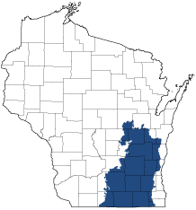
Southeast Glacial Plains
Ecological Landscape
Download the Southeast Glacial Plains chapter [PDF] of the Ecological Landscapes of Wisconsin. This chapter provides a detailed assessment of the ecological and socioeconomic conditions for the Southeast Glacial Plains.
It also identifies important planning and management considerations and suggests management opportunities that are compatible with the ecology of the landscape. The tabs below provide additional information.
- Physical and Biotic Environment
-
Physical and Biotic Environment
Size 7,725 square miles (4,943,731 acres), representing 13.8% of the land area of the State of Wisconsin. Climate Typical of southern Wisconsin; mean growing season of 155 days, mean annual temperature is 45.9 deg. F, mean annual precipitation is 33.6 inches, and mean annual snowfall is 39.4 inches. The climate is suitable for agricultural row crops, small grains, and pastures, which are prevalent in this Ecological Landscape. Bedrock Primarily underlain by limestone and dolomite with some sandstone and shale. Generally covered by a thick layer of glacial deposits (>50 feet). The southernmost exposures of the Silurian dolomite "Niagara Escarpment" occur west and south of Lake Winnebago. Geology & Landforms The dominant landforms are glacial till plains and moraines composed mostly of materials deposited during the Wisconsin Ice Age, but the southwestern part of the Ecological Landscape consists of older, pre-Wisconsin till and the topography is more dissected. Other glacial landforms, including drumlins, outwash plains, eskers, kames and kettles are also well-represented kames, eskers, and kettles. The "Kettle Moraine" is an area of rough topography on the eastern side of the Southeast Glacial Plains that marks the areas of contact between the Green Bay and Lake Michigan glacial lobes. Numerous excellent examples of glacial features occur and are highly visible in the Kettle Moraine. Soils Soils are derived from lime-rich tills overlain in most areas by a silt-loam loess cap. Hydrology The Southeast Glacial Plains has the highest aquatic productivity for plants, insects, other invertebrates, and fish of any Ecological Landscape in the state. Significant river systems include the Wolf, Bark, Rock, Fox, Milwaukee, Sugar, Mukwonago, and Sheboygan. Most riparian zones have been degraded. Several clusters of large lakes exist, including the Yahara chain of lakes in and around Madison, and the Lake Winnebago Pool system. Kettle lakes occur within end moraines, in outwash channels, and in ancient riverbeds. This Ecological Landscape contains some huge marshes, as well as fens, sedge meadows, wet prairies, tamarack swamps, and floodplain forests. Many wetlands here have been affected by hydrologic modifications (ditching, diking, tiling), grazing, infestations of invasive plants, and excessive inputs of sediment- and nutrient-laden runoff from croplands. Current Landcover Primarily agricultural cropland (58% of Landscape). Remaining forests occupy only 11% of the land area and major covertypes include maple-basswood, oak, lowland hardwoods, and conifer swamps (mostly tamarack-dominated). No large areas of upland forest exist except on the Kettle Interlobate Moraine, where the topography is too rugged to practice intensive agriculture and the soils are not always conducive to high crop productivity. Wetlands are extensive (12% of Landscape, 593,248 acres) and include large marshes and sedge meadows, and extensive forested lowlands within the Lower Wolf River floodplain. Forested lowlands are also significant along stretches of the Milwaukee, Sugar, and Rock rivers. - Associated Rare Species and Natural Communities
-
Associated Rare Species and Natural Communities

Species of Greatest Conservation Need (SGCN) are associated with habitats (or natural communities) and places on the landscape. Understanding relationships among SGCN, natural communities and ecological landscapes help us make decisions about issues affecting SGCN and their habitat and how to respond. Download the Wildlife Action Plan association score spreadsheet to explore rare species and natural communities associated with this ecological landscape.
- General Management Opportunities
-
General Management Opportunities
Although large portions of the Southeast Glacial Plains are now intensively developed agricultural or urban-industrial lands, there are major opportunities to maintain natural communities and provide critical habitat for many native species. Opportunities for managing on a larger scale are limited to a few areas.
The Kettle Moraine region features the least developed uplands in the entire landscape, much of it within the units of the Kettle Moraine State Forest (KMSF). Collectively, the KMSF arguably comprises the largest and most ecologically important public landholding in this part of the state. The Northern Unit of the KMSF features extensive upland forests, conifer and ash swamps, lakes, springs, marshes, Ephemeral Ponds and significant stretches of the Milwaukee River and its tributaries. This area is now southeastern Wisconsin's major breeding site for forest interior species, especially birds. There are opportunities here to develop, maintain and enlarge blocks of contiguous forested habitat that include large patches of older mesic and oak-dominated forests, patches of young forest, dense brush and areas where high contrast edge has been reduced.
The Southern Unit of the KMSF is a major repository of rare and diminished natural communities, especially oak savannas and woodlands, wet prairies, fens, sedge meadows and relict bogs. Each of these is a high priority for conservation because they are rare on state or global levels, include the best remaining occurrences and/or support many rare native plants and animals. Wisconsin's largest native grassland protection and restoration project, the Scuppernong River Habitat Area, is located within the KMSF - Southern Unit. Fire suppression, successional processes and tree planting have created blocks of forest in the Southern Unit of the KMSF that are now large enough to provide critical nesting habitat for forest interior species. Determining where to maintain such semi-natural habitats versus where to actively restore the globally rare savanna and woodland communities can be challenging and controversial, even where the protection and maintenance of biodiversity is a primary management objective.
Some wetlands in the Southeast Glacial Plains are large, in good condition and provide critical habitat for a host of sensitive species including large populations of breeding and migratory waterbirds, as well as other wetland inhabitants. Emergent marsh (including Horicon Marsh, the Upper Midwest's largest cat-tail marsh) is especially well-represented, but sedge meadow, calcareous fen, wet prairie and tamarack swamp are also important. The large complex of sedge meadow, marsh and wet prairie associated with the White and Puchyan rivers is also outstanding in terms of size and quality. The Lower Wolf River corridor features the most extensive forested floodplain in eastern Wisconsin and one of the largest emergent marshes.
The Mukwonago River watershed is the most intact watershed in this Ecological Landscape, as it features a spring-fed river system supporting a high diversity of fishes and aquatic invertebrates, extensive and floristically rich wetlands and is associated with remnant rare natural communities such as tallgrass prairie, calcareous fen, oak openings, oak woodland and relict bogs. Many rare species have been documented here. Private and public partners are working to protect, manage and restore many components of this watershed.
Lakes are concentrated in several areas, sometimes in association with end moraines, other times occupying glacial lakebeds and outwash channels. Shallow lakes are well-represented, and some of these are associated with extensive wetlands of marsh, sedge meadow and shrub-carr. Noteworthy warmwater streams include the Wolf, Mukwonago (some of the upper stretches are classified as "Coolwater"), Rock, Crawfish, Sugar, Milwaukee and Bark rivers. Most lakes here are now heavily developed.
Miscellaneous features of significance include southern Wisconsin's westernmost stands of mesic maple-beech forest, hardwood swamps, bog relicts and scattered surrogate grasslands. The southern extremities of the Niagara Escarpment occur here and provide habitat for rare invertebrates and plants, as well as the largest bat hibernaculum in the Upper Midwest.
- Considerations for Property Planning
-
Considerations for Property Planning
The Southeast Glacial Plains is heavily developed and highly populated. Pressure on natural resources, including ground and surface waters, is high and unlikely to diminish in the short-term. The amount of impervious surface is increasing in some watersheds, raising concerns about our ability to protect sensitive aquatic life and associated wetlands. Fragmentation is severe and isolation of native habitats is a major concern. Many invasive species are now widespread, well established, and have expanding populations here. Public ownership is limited and partnerships between public and private partners will be essential to accomplish long-term management goals and objectives for natural resources.
The Southeastern Wisconsin Regional Planning Commission (SEWRPC) has conducted biological inventories for the seven counties in which they have jurisdiction and identified important natural areas and sensitive species populations; all seven of the SEWRPC counties are at least partially located within the Southeast Glacial Plains Ecological Landscape. The Wisconsin DNR has also conducted biological inventory work throughout the Southeast Glacial Plains.
While in general reconnecting isolated habitat patches is a positive, and ultimately often necessary, action, when habitats lacking invasives are identified planners and other stakeholders need to be sure be sure that pathways for colonization by invasive species have not been created or increased, and that control measures for both existing and future problems created by these species are anticipated and built into management plans and the budgeting process.
For the two units of the Kettle Moraine State Forest, and at some of the larger wetland complexes (such as those at Horicon, along the Lower Wolf River, Sugar, and Milwaukee rivers, or in the Mukwonago River Watershed, planning at large scales will have many benefits to best ensure long-term viability of the resources present, as those areas offer many opportunities that smaller more isolated sites cannot.
- Maps
-
Maps
Printable maps of ecological landscapes are available in the Ecological Landscapes of Wisconsin document and map library.
Many of the map layers, such as Land Type Associations, Conservation Opportunity Areas and Finley’s 1800s vegetation polygons are available to download from the WI DNR GIS Open Data portal.