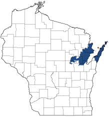
Northern Lake Michigan Coastal
Ecological Landscape
Download the Northern Lake Michigan Coastal chapter [PDF] of the Ecological Landscapes of Wisconsin. This chapter provides a detailed assessment of the ecological and socioeconomic conditions for the Northern Lake Michigan Coastal.
It also identifies important planning and management considerations and suggests management opportunities that are compatible with the ecology of the landscape. The tabs below provide additional information.
- Physical and Biotic Environment
-
Physical and Biotic Environment
Size 2,004 square miles (1,282,877 acres), representing 3.6% of the land area of the State of Wisconsin. Climate Cold winters and warm summers are moderated by the thermal mass of Lake Michigan, especially in coastal areas. The mean growing season is 140 days, mean annual temperature is 42.8 deg. F, mean annual precipitation is 32.1, and mean annual snowfall is 46 inches. Lake effect snow can be significant, especially along Lake Michigan. Rainfall and growing degree days are adequate to support agricultural row crops, small grains, hay and pastures. Warmer temperatures near Lake Michigan in fall and early winter and slightly cooler temperatures during spring and early summer are favorable for growing cherries, apples, and other fruits on the Door Peninsula. Bedrock Primarily underlain by Silurian dolomite but with some sandstone, also igneous and metamorphic rocks. Generally, the land is covered by a layer of soils of glacial origin; in some places, such as on the Door Peninsula and in the Grand Traverse Islands, the depth to bedrock is only a few feet or less from the surface. Geology & Landforms The Niagara Escarpment is a prominent bedrock ridge of Silurian dolomite that is exposed as cliffs and ledges along the western edge of the Door Peninsula and in the Grand Traverse Islands. The same bedrock is also exposed at many locations along the east side of the northern Door Peninsula, where it forms broad, nearly level bedrock shorelines. A broad, level lacustrine plain occurs in areas bordering the west shore of Green Bay, where an extensive delta has been created at the mouth of the Peshtigo River. Landforms along the Lake Michigan shore include beaches, dunes, baymouth bars, and complex ridge and swale topography. Embayment lakes and freshwater estuaries are also characteristic of the Lake Michigan shore. Elsewhere in this Ecological Landscape, ground moraine is the dominant landform. Soils Soils are diverse; in some areas, lacustrine sands are found overlying clays, or bedrock which is within a few feet of the surface. On the Door Peninsula soils are calcareous, typically stony loamy sands to loams. Shallow soils and exposures of dolomite bedrock are frequent near the Lake Michigan and Green Bay coasts. Poorly drained sands are common in the lake plain west of Green Bay and in depressions between dunes and beach ridges. Beyond the lake plain west of Green Bay, the ground moraine is composed mostly of moderately well-drained, rocky sandy loams, interspersed with lacustrine sands and clays. Peats and mucks are common along the west shore of Green Bay and in the northwestern part of the Ecological Landscape. There is an area of sandy soils between Stiles and Oconto Falls west of Green Bay. Chambers Island has "sandy, gravelly, clayey soils". Hydrology Lake Michigan is cold, deep, oligotrophic, and relatively clean; Green Bay, an estuary that is also the largest bay on Lake Michigan, is warm, shallow, productive, and dynamic. It has been heavily polluted, especially by industries that formerly dumped wastes into the Fox River at the head of the bay (which is within the Central Lake Michigan Coastal Ecological Landscape). The larger rivers that flow through this Ecological Landscape into Green Bay include the Menominee, Oconto, Peshtigo, and Pensaukee. These rivers and their tributaries drain the uplands west of Green Bay before passing through the extensive wetlands along Green Bay's west shore. Several large embayment lakes (e.g., Clark, Europe, and Kangaroo lakes) occur along the east side of the northern Door Peninsula. There are few large inland lakes. Several impoundments constructed on rivers west of Green Bay had been subjected to high levels of pollution from past industrial activity. On the Door Peninsula there have been serious groundwater contamination problems from agricultural pesticides and manure. These pollutants were able to reach the groundwater through the fractured dolomite bedrock. The lower Wolf River drains the westernmost part of this Ecological Landscape. Current Landcover Historically, the uplands were almost entirely covered by forest. Today, more than 64% is non-forested. Most of this land is now in agricultural crops (51%), with smaller amounts of grassland (5.6%), non-forested wetlands (6.1%), shrubland 0.1%), and urbanized areas (0.8%). The most abundant cover type in the forested uplands (262,119 acres or 20.4% of the Ecological Landscape) is maple-basswood, with smaller amounts of aspen-birch. Forested wetlands (mostly lowland hardwoods, with some conifer swamps) cover slightly over 14% of the area. Other cover types are comparatively scarce but of high importance ecologically, and include maple-beech, hemlock-hardwoods, white pine, and mixtures of boreal conifers (dominants include white spruce-balsam fir-white pine-white cedar). Important non-forested wetland communities include marsh, sedge meadow, and shrub swamp. - Associated Rare Species and Natural Communities
-
Associated Rare Species and Natural Communities

Species of Greatest Conservation Need (SGCN) are associated with habitats (or natural communities) and places on the landscape. Understanding relationships among SGCN, natural communities and ecological landscapes help us make decisions about issues affecting SGCN and their habitat and how to respond. Download the Wildlife Action Plan association score spreadsheet to explore rare species and natural communities associated with this ecological landscape.
- General Management Opportunities
-
General Management Opportunities
The Northern Lake Michigan Coastal Ecological Landscape borders Lake Michigan and Green Bay, encompassing over 200 miles of Great Lakes coast. The shorelines and related habitats, some of them unique to the Great Lakes, are used during the spring and fall by large numbers of migratory birds. In recent years, tens of thousands of diving ducks have been recorded wintering in offshore Lake Michigan habitats. Both Lake Michigan and Green Bay are highly significant for fish.
Large rookeries of colonial fish-eating birds occur on islands in Green Bay and Lake Michigan. Green Bay's low-lying west shore features extensive wetlands of marsh, sedge meadow, shrub swamp and hardwood swamp. The remnant conifer-hardwood forests on the Door Peninsula's margins support diverse populations of breeding birds and are also heavily used by many migrants.
The northern Door Peninsula and associated Grand Traverse Islands present conservation opportunities offered nowhere else in Wisconsin. Unusual physiographic features such as ridge and swale complexes, embayment lakes and freshwater estuaries are rich in rare natural communities, including beach, dune, bedrock shore, coastal fen and boreal forest. These, in turn, support one of Wisconsin's greatest concentrations of rare species, some of them endemic to Great Lakes shoreline environments.
The dolomite Niagara Escarpment is a dominant geological feature of this landscape. On the west side of the Door Peninsula the Escarpment is exposed as cliffs, ledges and talus slopes. Springs and seeps are present, and some of Wisconsin's oldest trees grow on the Escarpment. To the east, along Lake Michigan, the same bedrock forms extensive horizontal rock "beaches."
Scattered features of ecological importance include a stretch of the Menominee River at the northern edge of the landscape; a concentration of rich conifer swamps in the poorly drained terrain east and north of Lake Noquebay; extensive dry forests of aspen, oak and pine on sandy soils in southern Oconto County; warmwater rivers and streams entering Green Bay from the west; and the northernmost stretch of the Lower Wolf River.
Management opportunities vary greatly in different parts of the Northern Lake Michigan Coastal Ecological Landscape because of its variability. The factors responsible for this include the past and present influence of Lake Michigan and Green Bay, the dolomite bedrock, the composition of the glacial till and the highly variable landforms and their effects on land use. Because of this heterogeneity, Landtype Associations, which are fully described in the handbook chapter on the Northern Lake Michigan Coastal Ecological Landscape, can be helpful in identifying, describing and framing management opportunities in greater detail at appropriate locations and at larger scales in this landscape.
- Considerations for Property Planning
-
Considerations for Property Planning
The ecosystems of Lake Michigan, Green Bay, and the West Shore wetlands have changed dramatically in a short period of just a few years in recent decades. Conservation plans must be highly adaptive, coordinated, and integrated. Increasing development, skyrocketing land prices, and increasing recreational pressure on a limited land base are placing serious constraints on conservation efforts on the Door Peninsula. Pollutants in Green Bay have created serious management problems, especially for fish and fish-eating birds, and by extension, potentially for humans. The shallow soils and fractured bedrock of the Door Peninsula and Grand Traverse Islands makes sustainable development and water management challenging and expensive. The rapid spread of invasive species over the past several decades is overwhelming managers and agency budgets and is exacerbated by the large number and high mobility of visitors (including tourists, and commercial ships from other parts of the world), especially to the Door Peninsula, Grand Traverse Islands, and Green Bay West Shore. Browse pressure from high populations of white-tailed deer is having negative impacts on many of the native ecosystems and plant communities in this Ecological Landscape, especially on the biologically-diverse Door Peninsula.
- Maps
-
Maps
Printable maps of ecological landscapes are available in the Ecological Landscapes of Wisconsin document and map library.
Many of the map layers, such as Land Type Associations, Conservation Opportunity Areas and Finley’s 1800s vegetation polygons are available to download from the WI DNR GIS Open Data portal.