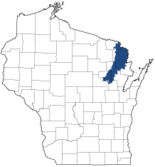
Northeast Sands
Ecological Landscape
Download the Northeast Sands chapter [PDF] of the Ecological Landscapes of Wisconsin. This chapter provides a detailed assessment of the ecological and socioeconomic conditions for the Northeast Sands.
It also identifies important planning and management considerations and suggests management opportunities that are compatible with the ecology of the landscape. The tabs below provide additional information.
- Physical and Biotic Environment
-
Physical and Biotic Environment
Size 1,542 square miles (987,176 acres), representing 2.8% of the land area of the state, making it the fifth smallest Ecological Landscape in the state. Climate The short growing season (122 days) is similar to other northern Ecological Landscapes and limits yield potential for row crop agriculture. January minimum temperatures average higher than other northern Ecological Landscapes. The average August maximum temperature (78.8o) is the third coolest of any other Ecological Landscape in the state. Bedrock Precambrian bedrock of volcanic and metamorphic origin, formed during the Lower Proterozoic (roughly 2,500 to 1,050 million years ago) almost completely underlies the Northeast Sands. The northern part of the Ecological Landscape is notable for its many waterfalls, almost all of which are associated with this ancient bedrock. Cambrian sandstone, with some dolomite and shale, underlies a small area along the eastern edge of the Ecological Landscape. In some places, glacial deposits are thin enough that bedrock directly affects vegetation, and is sometimes exposed at the surface. Geology & Landforms The Green Bay Lobe covered this Ecological Landscape during the last part of the Wisconsin Glaciation. As the Green Bay Lobe melted and retreated eastward, outwash was deposited over lower-lying surface features, so the Ecological Landscape now appears as a nearly level to rolling sandy outwash plain, pitted in places, with sandy heads-of-outwash and loamy moraines protruding through the outwash sediment. Heads-of-outwash, uncommon in most of Wisconsin, are a distinctive glacial feature here. A series of north-south trending morainal and head-of-outwash hills runs the length of the west side of this Ecological Landscape. They are oriented in roughly parallel positions, marking the outer extent of Green Bay Lobe deposits in northeastern Wisconsin. Soils Most upland soils formed in acid outwash sand on outwash plains or outwash heads. The dominant soil is excessively drained and sandy with a loamy sand surface, rapid permeability, and very low available water capacity. More than half the land surface is made up of outwash sand and gravel. Glacial till deposits here have pH values that are neutral to calcareous, unlike the acid tills of most of northern Wisconsin, because dolomite was incorporated into the till as glaciers passed over the Niagara Escarpment. Hydrology Rivers and streams include the Menominee, Peshtigo, Pike, Pine, Oconto, South Branch of the Oconto, and Wolf rivers. Scattered lakes are present, with local concentrations of small lakes in the far north, far south, and the northeast. Several large impoundments have been constructed, such as those on the Menominee and Peshtigo rivers. Hwy 64 bisects the Brazeau Swamp, one of Wisconsin's largest cedar swamps, disrupting its hydrology and altering composition and function. A large portion of this swamp was cleared and drained and is now a "muck farm" used to grow vegetables. Current Landcover Forests cover about 75% of this Ecological Landscape. Aspen is the most abundant cover type, and dry forests dominated by scrub-oak and jack pine are common. Plantation-grown pine, hemlock-hardwoods and northern hardwoods are also among the important upland cover types. Common lowland communities include wet-mesic forests dominated by northern white cedar, black spruce-tamarack swamps, and alder-dominated shrub swamps. Agriculture (only 7% of the area) is concentrated mostly in the southeastern and northernmost portions of the Ecological Landscape. - Associated Rare Species and Natural Communities
-
Associated Rare Species and Natural Communities

Species of Greatest Conservation Need (SGCN) are associated with habitats (or natural communities) and places on the landscape. Understanding relationships among SGCN, natural communities and ecological landscapes help us make decisions about issues affecting SGCN and their habitat and how to respond. Download the Wildlife Action Plan association score spreadsheet to explore rare species and natural communities associated with this ecological landscape.
- General Management Opportunities
-
General Management Opportunities
Roughly 75% of the Northeast Sands is forested, playing an important role in the landscape's high water quality, providing extensive forest habitat, supporting local economies and offering many management opportunities. Opportunities exist to maintain large habitat patches and improve connectivity between smaller forest patches; both of these would help avoid problems associated with fragmentation and isolation and should benefit area-sensitive species. Older forests are scarce here, as they are in most of the state, and working forests could include areas with extended rotations, the development of old-growth characteristics and/or stands of "managed old-growth."
Dry forest types are prevalent, but many other types are also significant. Many forests here are now managed for aspen, but there are good opportunities to maintain dry forests of other early successional species such as jack pine and scrub oak, as well as older mesic forests of beech-hemlock, dry-mesic forests of white and red pine and wet-mesic forests of white cedar. Northern Wet-mesic Forests dominated by white cedar are common here; these forests have high ecological value and support numerous rare or uncommon plants and animals, but they are susceptible to negative impacts from hydrological modifications and excessive browse pressure. Good opportunities to protect this fragile natural community occur on the Chequamegon-Nicolet National Forest, within several state wildlife areas and on the Marinette and Oconto County Forests.
Barrens and bracken grassland communities, once a much more common feature here, represent important restoration and management opportunities, and active projects are underway at several locations. Some of these projects could be expanded and/or made more compatible with management of adjoining dry forests. Where possible, early successional forests could be managed in association with remnant barrens and bracken grasslands to increase connectivity between open areas that are now isolated, increasing effective habitat size, reducing undesirable edge impacts and supporting additional open country animals.
Several Northeast Sands streams offer opportunities to protect aquatic habitats of high biodiversity value. There are good opportunities to protect and maintain river and stream corridors, including those of the Menominee, Peshtigo, Oconto, Wolf, Pine, Pike and some of their tributaries. Some of the streams are bordered by bedrock outcroppings, stands of conifers and/or relatively old forest, which support, or have the potential to support, species that are rare elsewhere in the Ecological Landscape and surrounding region.
Bedrock features, such as cliffs, glades and talus slopes, are well represented in some parts of the Northeast Sands, and these merit protection for their unusual biota, as well as the aesthetic and recreational interest they stimulate. Other miscellaneous features of potentially high local and regional ecological value include undeveloped lakes and ponds, bogs, fens, sedge meadows, marshes and alder swamps.
- Considerations for Property Planning
-
Considerations for Property Planning
Public lands are extensive, and there are significant tribal holdings in the southern part of the Northeast Sands. As in other parts of Wisconsin, high populations of white-tailed deer continue to have significant negative impacts on important forest dominants such as northern white cedar and eastern hemlock, as well as on understory composition and structure. Hydrologic modifications include large dams on several of the major rivers, including the Menominee, Peshtigo, and Pine. Shoreline development, especially along rivers and streams, is a significant concern and is likely to increase in the future. Several invasive species are established here, and others are likely to appear in the near future. There is currently a shortage of older forest and large forest patches; these issues could be addressed during the public lands planning process. Prescribed fire is a potentially important management tool at many locations in this Ecological Landscape. Jack pine, scrub oak, and aspen are all well-represented and important tree species to manage here.
- Maps
-
Maps
Printable maps of ecological landscapes are available in the Ecological Landscapes of Wisconsin document and map library.
Many of the map layers, such as Land Type Associations, Conservation Opportunity Areas and Finley’s 1800s vegetation polygons are available to download from the WI DNR GIS Open Data portal.