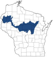
Forest Transition
Ecological Landscape
Download the Forest Transition chapter [PDF] of the Ecological Landscapes of Wisconsin. This chapter provides a detailed assessment of the ecological and socioeconomic conditions for the Forest Transition.
It also identifies important planning and management considerations and suggests management opportunities that are compatible with the ecology of the landscape. The tabs below provide additional information.
- Physical and Biotic Environment
-
Physical and Biotic Environment
Size 7,279 square miles (4,658,498 acres), representing 12.9% of the land area of the State, making it the fourth largest Ecological Landscape in the state. Climate Because this Ecological Landscape extends east-west across much of Wisconsin, the climate is variable. In addition, it straddles a major eco-climatic zone (the "Tension Zone) that runs southeast-northwest across the state. The mean growing season is 133 days, mean annual temperature is 41.9 deg. F, mean annual precipitation is 32.6, and mean annual snowfall is 50.2 inches. The growing season is long enough that agriculture is viable, although climatic conditions are not as favorable for many crops as they are in southern Wisconsin. Bedrock Throughout most of the Forest Transition, the uppermost layer of bedrock is Precambrian volcanic and metamorphic rock. Precambrian bedrock underlies the eastern portion of the Ecological Landscape, roughly east of U.S. Hwy. 13, and also underlies a small area at the far western end in Polk County. A large area in the west-central part is underlain by Cambrian sandstones with inclusions of dolomite and shale. A small area in Polk County is underlain by Ordovician dolomite. Geology & Landforms The Forest Transition was entirely glaciated. The central portion was formed by older glaciations, both Illinoian and pre-Illinoian, while the eastern and western portions are covered by deposits of the Wisconsin glaciation. Glacial till is the major type of material deposited throughout, and the prevalent landforms are till plains or moraines. Throughout the area, post-glacial erosion, stream cutting, and deposition formed floodplains, terraces, and swamps along major rivers. Wind-deposited silt material (loess) formed a layer 6 to 24 inches thick. Soils Most soils are non-calcareous, moderately well-drained sandy loams derived from glacial till, but there is considerable diversity in the range of soil attributes. The area includes sandy soils formed in outwash, as well as organic soils, and loam and silt loam soils on moraines. There are many areas with shallow soils. Drainage classes range from poorly drained to excessively drained. Density of the till is generally high enough to impede internal drainage, so there are many lakes and wetlands in most parts of the Forest Transition. Soils throughout the Ecological Landscape have silt loam surface deposits formed in aeolian loess, about 6 to 24 inches thick in much of the area. Hydrology Major river systems draining this Ecological Landscape include the Wolf, Wisconsin, Black, Chippewa, and St. Croix. Current Landcover Landcover is highly variable by subsection, dominant landform, and major land use. The eastern part of the Ecological Landscape remains heavily forested, the central portion is dominated by agricultural uses (with most of the historically abundant mesic forest cleared), and the west end is a mixture of forest, lakes, and agricultural land. - Associated Rare Species and Natural Communities
-
Associated Rare Species and Natural Communities

Species of Greatest Conservation Need (SGCN) are associated with habitats (or natural communities) and places on the landscape. Understanding relationships among SGCN, natural communities and ecological landscapes help us make decisions about issues affecting SGCN and their habitat and how to respond. Download the Wildlife Action Plan association score spreadsheet to explore rare species and natural communities associated with this ecological landscape.
- General Management Opportunities
-
General Management Opportunities
Once almost completely forested, the Forest Transition's largest blocks of forests are now limited to certain areas. Portions of two large forested areas, the Lakewood-Laona District of the Chequamegon-Nicolet National Forest (CNNF) and the Menominee Indian Reservation, comprise the easternmost and most densely forested end of the landscape. These are largely mesic forests, and the forests of the Menominee Reservation have retained some old forest attributes, including large trees, coarse woody debris and multi-layered canopies. Unlike many other parts of Wisconsin, eastern hemlock remains abundant in some areas, and both it and northern white cedar can be found reproducing here. These forests provide important habitats that are rare or absent elsewhere and offer excellent opportunities for monitoring and research.
Roughly two hundred miles west of the Menominee Reservation, at the westernmost end of the landscape, forests also occur in large blocks. These very different forests are generally less contiguous and are largely dry-mesic. They can contain a strong red and white oak component, and scattered areas contain significant amounts of white pine. These forests offer opportunities to identify high conservation value areas, reduce fragmentation, are known to support rare forest interior birds and may be important for long-term monitoring since they can contain species at their northernmost range limits.
Much of this landscape is now quite open and dominated by intensive agricultural use. A few open areas of surrogate grassland (non-native grasses) and adjacent wetlands embedded within agricultural lands are large enough to support declining grassland birds, including the WI Threatened Greater Prairie Chicken. There are opportunities to maintain, enlarge and connect these habitats to better support area sensitive species. However, other open areas provide re-forestation opportunities to increase the size of forested blocks, provide habitat, improve water quality, reduce hard edge and help local economies over the long-term.
Protecting undeveloped lakes, ponds and streams is a major opportunity. Lakes and wetlands on the CNNF associated with the Green Bay Glacial Lobe can be somewhat calcareous, and some of these alkaline waters and wetlands support rare or otherwise unusual plants. The Polk County portion of the landscape contains numerous lakes associated with the St. Croix Moraine. Extensive wetlands, most of them forested, occur at the southern margins of several end moraines.
Maintaining intact river corridors is a major opportunity in the Forest Transition. A number of rivers cross the landscape from north to south, including the Wolf, Chippewa and St. Croix, all of which support high aquatic biodiversity and many rare species. Wetlands and forests forming the corridors of these rivers are used heavily by migratory birds and may be important for other species traveling between northern and southern Wisconsin. Habitats such as floodplain forest and marsh are better represented along the large rivers than elsewhere in the landscape.
Bedrock exposures, though localized and uncommon, can provide specialized habitats. Significant outcroppings of Precambrian rock in the Forest Transition include exposures of granites, quartzite and basalt as cliffs, glades and talus slopes in certain areas. Cambrian sandstone exposures occur at a few locations such as the south central part of the landscape.
- Considerations for Property Planning
-
Considerations for Property Planning
The Forest Transition stretches east to west across most of Wisconsin north of the Tension Zone and is quite heterogeneous. This Ecological Landscape has lost over half of its historic forests (though this is highly variable in different areas), and overall, is one of the most deforested landscapes north of the Tension Zone. Areas to the east remain heavily forested, the central areas are open and intensively farmed, and the western end is a mosaic of agricultural land, forest, and recreational lands. West of the Green Bay Lobe Stagnation Moraine Subsection (see glossary - this term comes from the National Hierarchical Framework of Ecological Units) this Ecological Landscape is highly fragmented, limiting most forest and grassland habitats and large-scale management opportunities. Large power dams occur on several of the major rivers, including the Wisconsin, Chippewa and St. Croix. Public ownership is uneven and concentrated along several of the larger rivers, as well as in some of the more heavily forested areas.
- Maps
-
Maps
Printable maps of ecological landscapes are available in the Ecological Landscapes of Wisconsin document and map library.
Many of the map layers, such as Land Type Associations, Conservation Opportunity Areas and Finley’s 1800s vegetation polygons are available to download from the WI DNR GIS Open Data portal.