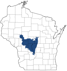
Central Sand Plains
Ecological Landscape
Download the Central Sand Plains chapter [PDF] of the Ecological Landscapes of Wisconsin. This chapter provides a detailed assessment of the ecological and socioeconomic conditions for the Central Sand Plains.
It also identifies important planning and management considerations and suggests management opportunities that are compatible with the ecology of the landscape. The tabs below provide additional information.
- Physical and Biotic Environment
-
Physical and Biotic Environment
Size 3,420 square miles (2,188,861 acres), representing 6.1% of the land area of the State of Wisconsin. Climate Typical of southern Wisconsin, mean annual temperature is 43.8 deg. F, mean annual precipitation is 32.8 inches, and mean annual snowfall is 45.0 inches. However, the mean growing season (135 days) is almost 19 days less than other southern Wisconsin ecological landscapes. Summer temperatures can drop below freezing at night in low-lying areas, restricting the distribution of some native plants. The short growing season and summer frosts limit agriculture, especially west of the Wisconsin River where commercially-grown cranberries are an important crop. East of the Wisconsin River the growing season is somewhat longer (by approximately 11 days), with fewer nights of potential summer frost. In this area agriculture is focused primarily on cool season crops such as potatoes, vegetables, and early maturing corn. Center pivot irrigation is widely used to water crops in this region of sandy soils. Grazing is a common land use practice in some areas. Bedrock Late Cambrian sandstone that contains strata of dolomite and shale. Most exposures are of Cambrian sandstones. Precambrian igneous (granite) and metamorphic (gneiss) rocks lie beneath the sandstone and are exposed in a few places (e.g., in rapids on the Black River and East Fork of the Black River). Geology & Landforms An extensive, nearly level expanse of lacustrine and outwash sand that originated from a huge glacial lake characterizes much of the Central Sand Plains. Sand was deposited in Glacial Lake Wisconsin by outwash derived from melting glaciers to the north. Exposures of eroded sandstone bedrock remnants as buttes, mounds and pinnacles are unique to this Ecological Landscape. Sandstone is also exposed as cliffs along the Black River and some of its tributaries. Soils Most soils formed from deep sand deposits of glacial lacustrine or outwash origin or in materials eroded from sandstone hillslopes and sometimes with a surface of wind-deposited (aeolian) sand. These soils are excessively drained, with very rapid permeability, very low available water capacity, and low nutrient status. In lower-lying terrain where silty lacustrine material impedes drainage, the water table is very close to the surface. Such areas are extensive in the western part of the Ecological Landscape, where soils may be poorly drained with surfaces of peat, muck or mucky peat. Thickness of peat deposits ranges from a few inches to more than 15 feet. Hydrology Large areas of wetlands and a number of generally low-gradient streams that range from small coldwater streams to large warmwater rivers. Major rivers include the Wisconsin, Black, East Fork of the Black, Yellow, and Lemonweir. A number of headwaters streams originate in the extensive peatlands west of the Wisconsin River. Natural lakes are rare, and are limited to riverine floodplains and a few scattered ponds within the bed of extinct Glacial Lake Wisconsin. The hydrology of this Ecological Landscape has been greatly disrupted by past drainage, channelization, impoundment construction, and groundwater withdrawal. Current Landcover The eastern portion of the Central Sand Plains is a mosaic of cropland, managed grasslands and scattered woodlots of pine, oak, and aspen. Many of the historic wetlands in the east were drained early in the 1900s and are now used for agricultural purposes. The western portion of this Ecological Landscape is mostly forest or wetland. Oak, pine, and aspen are the most abundant forest cover types. Plantations of red pine are common in some areas. On wet sites the forests are of two major types: tamarack and black spruce in the peatlands, and bottomland hardwoods in the floodplains of the larger rivers. Many attempts to practice agriculture west of the Wisconsin River failed due to poor soils, poor drainage, and growing season frosts. - Associated Rare Species and Natural Communities
-
Associated Rare Species and Natural Communities

Species of Greatest Conservation Need (SGCN) are associated with habitats (or natural communities) and places on the landscape. Understanding relationships among SGCN, natural communities and ecological landscapes help us make decisions about issues affecting SGCN and their habitat and how to respond. Download the Wildlife Action Plan association score spreadsheet to explore rare species and natural communities associated with this ecological landscape.
- General Management Opportunities
-
General Management Opportunities
The Central Sand Plains surrounds a large acreage of publicly-owned lands and contains extensive blocks of a wide variety of habitats. It provides many landscape-scale management opportunities absent from other parts of Wisconsin, especially the southern half of the state where habitats are often highly fragmented and public ownership is limited.
Large forest blocks provide habitat for area-sensitive species and protect water quality. Extensive oak and pine forests are common and can be managed at all scales and age classes. Opportunities to develop and maintain old-growth characteristics are good for Northern Dry-mesic Forest, Southern Dry-mesic Forest, the mixed Central Sands Pine-Oak Forest, White Pine-Red Maple Swamp, Floodplain Forest, as well as some of the drier oak and pine types at certain locations. Floristically rich mesic hardwood forests on terraces just above the floodplains of several of the major rivers offer fewer, but important, opportunities. Early successional forest management opportunities are also good here, for jack pine, "scrub" oak and, locally, aspen.
Abundant wetlands provide excellent large-scale management opportunities, especially in and around the bed of the former Glacial Lake Wisconsin. Large acid peatland complexes support many species (plants and animals) known mostly from northern Wisconsin, along with species that are rare in the north. These wetlands can be managed in ways that are compatible with surrounding forest and/or open habitats, to maximize their utility for sensitive species.
Rare communities such as Oak and Pine Barrens, Coastal Plain Marsh, White Pine-Red Maple Swamp, are well-represented in the Central Sand Plains and support many rare species. Remnant barrens warrant additional recognition, protection, restoration and expansion, and in many areas could be managed compatibly with dry forests of jack pine and oak. East of the Wisconsin River extensive "surrogate grasslands" are managed for rare and declining grassland animals, including Wisconsin's best populations of the Greater Prairie-chicken and regal fritillary. In general, there are numerous opportunities to connect high-quality remnants of barrens, dry forest, sand prairie and other habitats and manage at multiple scales.
Major rivers such as the Wisconsin, Black, Yellow, Lemonweir and Eau Claire and their floodplains, provide extensive, contiguous habitats (especially floodplain forest) for many species of management concern. The river corridors can provide connectivity between habitats in this landscape and other ecological landscapes to the north, south and west. Headwaters streams originating in Central Sand Plains extensive peatlands could be restored, protected and managed as parts of entire riparian systems - a rare opportunity for the southern half of the state.
Sandstone bedrock exposures in the Central Sand Plains include unusual features such as buttes, mesas, mounds and pinnacles. These types of geological features are not found elsewhere in the state and some of them support rare and specialized plants and animals.
The Central Sand Plains is a major concentration area, of rare species, including several that are globally imperiled. A number of disjunct species, sometimes far from their primary ranges, are present. In addition, the landscape's location and its wide variety of habitats allow many plants and animals to occur near their southern or northern range limits.
- Considerations for Property Planning
-
Considerations for Property Planning
The extensive acreage of public lands, and the large amount of forest cover and wetlands in the western part of the Central Sand Plains, present unique opportunities for management at large scales. A small number of large private ownerships, rather than numerous small private ownerships, is a characteristic ownership pattern in some areas, and this may also facilitate management at large scales and potentially make the coordination of management on public and private lands more feasible. Integration of forest and barrens management is possible and highly desirable in some areas because of the type, suitability, and condition of the habitats present, the extensive acreage of public lands, and the relatively low levels of development. Partial restoration of some streams is possible by restoring meanders, removing dams, plugging ditches, and improving management on other lands within the watersheds. Groundwater withdrawals and contamination are concerns due to the sandy soils and high water table. Center pivot irrigation is common east of the Wisconsin River and has been increasing to the west of the Wisconsin. Use of prescribed fire as a management tool may be more feasible at large scales here than elsewhere in southern WI, and is appropriate for many forest, savanna, grassland, and wetland communities. Burn plans should incorporate refugia where needed to protect fire-sensitive species. The spread of invasive plants threatens natural communities and other habitats and is a growing management concern. Commercial cranberry farming has been expanding in recent years; sometimes into upland sites rather than wetlands.
- Maps
-
Maps
Printable maps of ecological landscapes are available in the Ecological Landscapes of Wisconsin document and map library.
Many of the map layers, such as Land Type Associations, Conservation Opportunity Areas and Finley’s 1800s vegetation polygons are available to download from the WI DNR GIS Open Data portal.