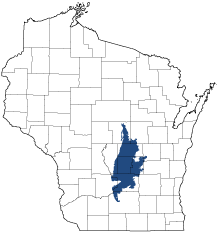
Central Sand Hills
Ecological Landscape
Download the Central Sand Hills chapter [PDF] of the Ecological Landscapes of Wisconsin. This chapter provides a detailed assessment of the ecological and socioeconomic conditions for the Central Sand Hills.
It also identifies important planning and management considerations and suggests management opportunities that are compatible with the ecology of the landscape. The tabs below provide additional information.
- Physical and Biotic Environment
-
Physical and Biotic Environment
Size 1,388,705 acres (2,170 square miles), representing 3.9 % of the land area of the State of Wisconsin. Climate Typical of south central Wisconsin; mean growing season of 144 days, mean annual temperature is 44.8 deg. F, average January minimum temperature is 4deg. F, average August maximum temperature is 81deg. F, mean annual precipitation is 33 inches, mean annual snowfall is 44 inches. Although the climate is suitable for agricultural row crops, small grains, and pastures, the sandy soils somewhat limit agricultural potential. Bedrock Bedrock exposures are limited but include Precambrian rhyolite bluffs, and a vertical exposure of Ordovician St. Peter sandstone with a thin dolomite cap at Gibraltar Rock in Columbia County. Geology & Landforms The landforms in this Ecological Landscape include a series of glacial moraines (the Johnstown Moraine is the terminal moraine of the Green Bay lobe; the Arnott Moraine is older, and has more subdued topography. Pitted outwash is extensive in some areas. Glacial tunnel channels occur here, e.g., in Waushara County, just east of and visible from I-39. Soils Soils are primarily sands. Organic soils underlie wetlands such as tamarack swamps and sedge meadows. Muck farming still occurs in some areas. Hydrology Mosaic of extensive wetlands and small kettle lakes in the outwash areas, and the headwaters of coldwater streams originating in glacial moraines. Some seepage lakes and ponds exhibit dramatic natural water level fluctuations which create important Inland Beach and Coastal Plain Marsh habitats. The Wisconsin River and a short but ecologically important stretch of the lower Baraboo River flow through this Ecological Landscape. Other important rivers include the Fox, Grand, Mecan, Montello, Puchyan, and White. Large impoundments occur on the Wisconsin (Lake Wisconsin), Fox (Buffalo and Puckaway lakes) and Grand (Grand River Marsh) rivers. Current Landcover Current vegetation is more than one-third agricultural crops, one third forest, and almost 20% grasslands with smaller amounts of open wetland, open water, shrubs, unvegetated (termed "barren" in WISCLAND), and urban areas. Large contiguous areas of any of the major natural or surrogate vegetation types are uncommon. - Associated Rare Species and Natural Communities
-
Associated Rare Species and Natural Communities

Species of Greatest Conservation Need (SGCN) are associated with habitats (or natural communities) and places on the landscape. Understanding relationships among SGCN, natural communities and ecological landscapes help us make decisions about issues affecting SGCN and their habitat and how to respond. Download the Wildlife Action Plan association score spreadsheet to explore rare species and natural communities associated with this ecological landscape.
- General Management Opportunities
-
General Management Opportunities
Fire-dependent communities were once common and widespread in the Central Sand Hills. Although today's examples are mostly small remnants, there are excellent opportunities to manage for fire-dependent and fire-adapted communities such as oak forest, oak woodland, oak savanna, tallgrass prairie, sedge meadow and fen. Remnant savannas, both Oak Barrens and Oak Openings, occur on dry and dry-mesic sites scattered throughout the Central Sand Hills. All of these communities have high potential to support rare plants, invertebrates and reptiles.
Dry forests of white, black and bur oak are common, though forest management at large scales is constrained by ownership patterns and small tract size and current land uses. Management of oak forests and woodlands could be integrated with management of oak savanna, prairie and wetlands. This would be especially appropriate on public and private lands managed mostly for conservation purposes. Mixed forests of pine and oak are locally common, and the Central Sand Hills is one of two ecological landscapes where good examples of the Central Sands Pine-Oak Forest community have been documented.
Large wetland complexes such as those found at Germania Marsh, Comstock Marsh, Grand River Marsh and Fountain Creek Prairie contain good examples of fen, sedge meadow, wet prairie, shrub swamp and tamarack swamp. The Central Sand Hills contains more occurrences of the globally rare Coastal Plain Marsh community than any other landscape in Wisconsin. Coastal Plain Marsh communities provide habitat for rare vascular plants and invertebrates and are associated with sandy or gravelly shores of seepage lakes that exhibit dramatic natural water level fluctuations. The US Threatened Fassett's locoweed is strongly associated with this and the inland beach communities. Floodplain forest is significant along stretches of the major rivers such as the Wisconsin, Baraboo and Montello and provides important habitat for resident and migratory wildlife.
Important warmwater rivers include the Fox, Montello, Baraboo and a short but ecologically significant stretch of the Wisconsin. This section includes Pine Island State Wildlife Area, an area associated floodplain habitats, as well as significant savanna and grassland remnants. Dams on several of the major rivers have created very large shallow impoundments, including Buffalo Lake, Lake Puckaway and Lake Wisconsin, and these offer valuable wildlife habitat but need rehabilitation to address their poor water quality. Green Lake, Wisconsin's deepest inland lake, is located in the east central portion of the Central Sand Hills.
Bedrock exposures are rare in the Central Sand Hills. However, they include good examples of glades, cliffs and talus slopes, which support rare plants and other unique vegetation, as well as some rare animals.
- Considerations for Property Planning
-
Considerations for Property Planning
Important concerns and considerations in the Central Sand Hills include the fragmentation and isolation of major habitats, groundwater withdrawals, ground and surface water contamination, hydrologic disruption due to ditching and diking, fire suppression and the loss of fire-dependent habitats and species, shoreline development, and the introduction and spread of invasive species. Poor water quality exists in some lakes and impoundments. Ground water contamination is also an issue in this Ecological Landscape. Excessive groundwater withdrawals could have serious negative consequences in areas supporting coldwater streams and seepage lakes, and within the recharge areas of groundwater-dependent natural communities such as Coastal Plain Marsh, Calcareous Fen, Tamarack Swamp, and Southern Sedge Meadow. Fire suppression has altered successional pathways that maintained savannas, prairies and other fire-adapted or dependent vegetation.
- Maps
-
Maps
Printable maps of ecological landscapes are available in the Ecological Landscapes of Wisconsin document and map library.
Many of the map layers, such as Land Type Associations, Conservation Opportunity Areas and Finley’s 1800s vegetation polygons are available to download from the WI DNR GIS Open Data portal.