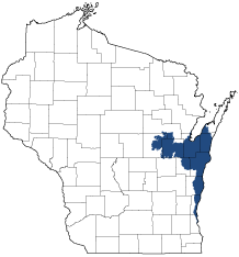
Central Lake Michigan Coastal
Ecological Landscape
Download the Central Lake Michigan Coastal chapter [PDF] of the Ecological Landscapes of Wisconsin. This chapter provides a detailed assessment of the ecological and socioeconomic conditions for the Central Lake Michigan Coastal.
It also identifies important planning and management considerations and suggests management opportunities that are compatible with the ecology of the landscape. The tabs below provide additional information.
- Physical and Biotic Environment
-
Physical and Biotic Environment
Size 2,742 square miles (1,755,089 acres), representing 4.9% of the land area of the State of Wisconsin. Climate The climate in the eastern part of this Ecological Landscape is moderated by its proximity to Lake Michigan, leading to warmer temperatures in the fall and early winter and somewhat cooler temperatures during spring and early summer that influence vegetation and other aspects of the ecology. Lake effect snow can occur in areas along the Lake Michigan coast during the winter. Mean growing season is 160 days (second longest in the state), mean annual temperature is 45.1 deg. F, mean annual precipitation is 31.1 (second lowest in the state), and mean annual snowfall is 43.4 inches. There is adequate rainfall and growing degree days to support agricultural row crops, small grains, and pastures which are prevalent land uses here. Bedrock Bedrock is mostly Silurian dolomite. It underlies all the counties along Lake Michigan, extending as far west as Lake Winnebago. It often appears as ridges or cliffs where surrounding bedrock has been eroded. Maquoketa shale occurs in a narrow strip along the Green Bay shoreline. West of Green Bay, the land is underlain by dolomitic rock with strata of limestone and shale. Further inland, bands of sandstone lie roughly parallel to the shore. An area in western Outagamie and eastern Shawano counties is deeply underlain by Precambrian granitic rocks. Where overlying glacial deposits are thin enough (e.g., in parts of the Door Peninsula), bedrock characteristics can directly affect the vegetation, especially where the substrate is strongly calcareous. Plant nutrients derived from limestone and dolomite have contributed to the development of unusual plant communities, and these in turn support rare or uncommon plants adapted to habitats containing high levels of calcium. Where dolomitic bedrock is close to the surface, runoff laden with sediments and pollutants can move quickly and over long distances through fractures in the rock. Geology & Landforms Landforms are mostly glacial in origin, especially till plains and moraines, reworked and overlain in the western part by Glacial Lake Oshkosh. Beach ridges, terraces, and dunes formed near the shorelines of this glacial lake when sandy sediments were present. At other locations boulder fields were formed when silts and clays were removed by wave action. Along Lake Michigan coastal ridge and swale complexes, drowned river mouths (freshwater estuaries), and clay bluffs and ravines occur. The Niagara Escarpment is a prominent bedrock feature that runs along the east sides of lower Green Bay and the Fox River Valley. Soils Most upland soils are reddish-brown calcareous loamy till or lacustrine deposits on moraines, till plains, and lake plains. The dominant soil is loamy or clayey with a silt loam surface, with moderately slow permeability, and high available water capacity. Hydrology Lake Michigan is a key ecological and socioeconomic feature. It influences the climate, created unique landforms, and is responsible in part for the presence and distribution of rare species. The shoreline constitutes a major flyway for migratory birds. Most of the major cities in this Ecological Landscape are located at the mouths of rivers entering Lake Michigan or Green Bay. Inland lakes are scarce, and all are small. The Fox River drains Lake Winnebago and runs into Green Bay. The other major rivers here run directly into Lake Michigan, and include the Ahnapee, Kewaunee, East Twin, West Twin, Manitowoc, Sheboygan, and Milwaukee. Current Landcover Agriculture is the dominant land use here by area, and there are several medium sized cities. Some large forested wetlands occur in both the eastern and western parts of the Ecological Landscape. The Wolf River bottoms are especially important in the west. Extensive marshes persist in southwestern Green Bay. The ridge and swale complex at Point Beach contains the largest area of coastal forest (with associated wetlands, dunes, and beaches) and constitutes an extremely important repository of regional biodiversity. - Associated Rare Species and Natural Communities
-
Associated Rare Species and Natural Communities

Species of Greatest Conservation Need (SGCN) are associated with habitats (or natural communities) and places on the landscape. Understanding relationships among SGCN, natural communities and ecological landscapes help us make decisions about issues affecting SGCN and their habitat and how to respond. Download the Wildlife Action Plan association score spreadsheet to explore rare species and natural communities associated with this ecological landscape.
- General Management Opportunities
-
General Management Opportunities
Lake Michigan forms the eastern boundary and is a dominant feature of the Central Lake Michigan Coastal Ecological Landscape. Most of the immediate shoreline is upland and has undergone extensive development to serve agricultural, residential, recreational and urban-industrial uses. Many important protection and management opportunities are associated with Lake Michigan shoreline features such as beaches and dunes, ridge and swale complexes, alvar, ravines with native conifers, coastal forests and marshes and migratory bird concentration areas.
A majority of the natural vegetation remaining in the western part of the landscape is associated with the Wolf River floodplain. Significant acreages of lowland hardwood forest, shrub swamp and marsh are present, along with smaller amounts of sedge meadow and mesic hardwood forest. The entire floodplain of the Wolf River merits protection, as almost everything around it is now heavily developed. Similarly, the only extensive areas of natural vegetation in the eastern part of the landscape are several isolated but large wetlands in southern Door and Kewaunee counties and at several other locations to the south and west. Most of these wetlands are forested, with stands of swamp hardwoods, white cedar, tamarack and floodplain forest. Much of this land is in multiple private ownerships, with relatively few large tracts. There is a need to conduct field surveys to identify sites that offer the best opportunities for management and protection partnerships.
Lake Michigan is used heavily by waterfowl and other waterbirds, and its shoreline is important for migratory birds of many kinds, including waterfowl, loons, grebes, gulls, terns, shorebirds, raptors and passerines. Providing or maintaining habitat for nesting, migratory and wintering birds along and near Lake Michigan and Green Bay are important conservation goals. Management opportunities include maintaining and restoring the integrity of locations on Lake Michigan and its shoreline that receive heavy bird use, as well as reforesting open locations along the shoreline for use as migratory stopover sites for land birds. There is also a need to provide stopover habitats at inland locations.
Old forests, a rare and declining resource in Wisconsin, present important opportunities for white pine, red pine, red oak, hemlock hardwoods, northern hardwoods and swamp conifers. Working forests, both public and privately owned, could include areas with extended rotations, the development of old-growth forest characteristics and/or stands of "managed old-growth."
Several miscellaneous features are of at least local importance in the Central Lake Michigan Coastal. Examples that represent management opportunities include river and stream corridors, inland lakes, Ephemeral Ponds, remnant maple-beech forests, pine-oak forests and Surrogate Grasslands, the latter include some Great Lakes shoreline sites.
- Considerations for Property Planning
-
Considerations for Property Planning
Fragmentation, especially of forested habitats, is severe in this Ecological Landscape. Many remnants of native vegetation are small and isolated, and there is not much public land. Where feasible, steps need to be taken to increase effective habitat area, and minimize isolation by connecting scattered remnants, especially along shorelines and waterways. Additional stopover sites for migratory birds are needed along the Lake Michigan shoreline. Invasive plants are a major problem in both upland and wetland vegetation types. The Lower Green Bay ecosystem continues to change rapidly; it seems unlikely that this area will stabilize in the immediate future. There is a need for an updated and expanded inventory of natural features here.
- Maps
-
Maps
Printable maps of ecological landscapes are available in the Ecological Landscapes of Wisconsin document and map library.
Many of the map layers, such as Land Type Associations, Conservation Opportunity Areas and Finley’s 1800s vegetation polygons are available to download from the WI DNR GIS Open Data portal.