Mississippi River - Frequently asked questions
Hunting
Where is it legal to hunt with a Wisconsin license?
You may hunt with a Wisconsin hunting license only in open hunting areas within Wisconsin. The commercial navigation channel, marked with large red or black buoys, is the state line in most places. A few exceptions exist where the main channel of the river was moved by the U.S. Army Corps of Engineers after the Wisconsin state line was established.
Water quality
- What is the present condition of the Mississippi River?
-
In many respects, the Upper Mississippi River is cleaner today than it was 30 years ago. Increased awareness of how pollution can negatively impact humans and the environment prompted passage of laws, such as the Clean Water Act, to protect our natural resources, however, the ecological condition of the Mississippi River and its tributaries is still rapidly being altered. Navigation, dredging, construction, wetland development, agricultural practices, urbanization, industrial waste discharges, invasive exotics and increased recreational use continue to take their toll.
- What factors determine water quality?
-
Many attributes are included when one talks about water quality. Some of the parameters measured such as dissolved oxygen, temperature and pH are readily recognized as being of the utmost importance to life in the river and are some of the easier parameters to measure. Many other parameters are measured including turbidity, nutrients such as nitrogen and phosphorus, chloride, metals, suspended solids and chlorophyll.
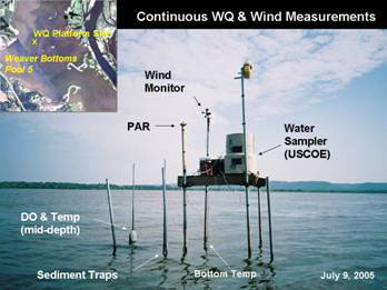
Water quality parameters can be measured continuously from a platform anchored in the river. Wind, dissolved oxygen, the amount of light, the temperature at various depths, sediment traps and water quality samples can be collected and monitored.
- What are the primary pollutants?
-
The Mississippi River is on the Wisconsin DNR state impaired water list for both mercury and PCBs. Long term monitoring of these contaminants has been conducted for over 20 years. Resource managers have recognized that sediment is a significant problem on the Mississippi River also.
- Tell me more about mercury and PCBs
-
- Polychlorinated Biphenyls (PCBs) are man-made chemicals that are colorless and odorless. Up until the late 1970s PCBs were widely used industrial chemicals because of the nature of their chemical and thermal stability. PCBs were used in fluorescent light fixtures, carbonless paper, adhesives, plastics, paints, varnishes and sealants, as well as for coolant insulation fluids in electrical equipment. The United States produced 1.5 billion pounds of PCBs between 1930 and 1975. Unfortunately, PCBs were later found to be dangerous chemicals. Their stable tendencies prevent their breakdown into less toxic chemicals and consequently, PCBs are quite persistent in the environment. Prolonged exposure to even small concentrations of PCBs can lead to health problems such as liver damage, cancer and growth and developmental problems. The Toxic Substances Control Act banned the manufacture of PCBs in open systems in 1979. Currently, PCBs are the river contaminants of greatest concern for Minnesota, Wisconsin and Iowa. PCBs were (or have been) a widespread problem on the Mississippi River which resulted in the closure of the commercial fishing on Lake Pepin in the mid-1970s. Monitoring has shown the presence of PCBs throughout the country, including areas isolated from PCB manufacturers. It is estimated that over seven billion pounds of PCBs have escaped into the environment via discharges to the air, land and water. The chemicals periodically escape during spills or when old equipment is discarded. When PCBs leach out of the landfills they end up in our rivers, lakes and air (through evaporation). Once these chemicals enter the aquatic environment, they are incorporated into the food chain, becoming progressively more and more concentrated in the upper levels of the food web. This process is called biomagnification.
- Mercury is a heavy metal that is routinely tested for in fish because it accumulates in the muscle tissue of animals and people. It can become biomagnified by the same process presented above. Some of the mercury in the environment is of a natural origin, but the majority stems from coal-burning power plants. Other sources of mercury have been dental amalgams, thermostats, thermometers and batteries. Because of the concern for mercury, there has been greater control over its use to prevent releases to the environment. Mercury concentrations in fish tissue have resulted in fish consumption advisories for many of our lakes and streams primarily from atmospheric deposition.
- Why is the river filling in or what is sedimentation?
-
The filling in of the Mississippi River and it's backwaters with the silt and sand particles, carried by the river is called sedimentation. Sedimentation is one of the rivers most serious problems and has numerous effects on the river:
- The accumulation of silt in the backwaters fills in important habitat for fish and wildlife and covers up spawning grounds.
- The silt transports pollutants like PCBs and heavy metals in the water. Phosphorus, a nutrient which in excess can lead to problems with algae blooms, can also be attached to the silt particles.
- The sand which accumulates in the main channel of the Mississippi River contributes to the high cost of dredging required to maintain the 9-foot navigation channel.
The Upper Mississippi River is particularly vulnerable to sedimentation not only because it drains such a vast land area but because the lock and dam system has changed the river’s natural movement of sediment. Prior to the building of the locks and dams, sediment was carried by the free-flowing river for long distances. However, the locks and dams transformed the river into a series of navigation pools with stabilized water levels, which reduced the speed of the current and as a result its ability to carry sediment.
The amount of material deposited in the lake-like areas that exist in the lower end of the pools depends on the length and size of the pools, for example, Lake Pepin which is long and large, acts as a settling trap for the silt and clay particles in the river. It is important to keep Lake Pepin from filling in as long as possible because it determines the health of the river below.
In general, the larger tributaries deliver the largest loads of sediment especially bed sediment. Some of the most significant contributors of sediment to the Upper Mississippi River are:
- In Minnesota, the Minnesota River carries six times as much sediment as the Mississippi River at that juncture. Much of the sediment carried by the Minnesota River settles in Lake Pepin.
- In Wisconsin, the Chippewa River contributes the most sediment followed by the Wisconsin River and Black River.
The rate of sedimentation varies for different parts of the river, but it can be substantial. For instance, in 1940 the land area of the delta where the Grant River joins the Mississippi River near Potosi, Wisconsin was 116 acres; by 1987 the delta had expanded to almost 500 acres in size.
- What are the sources of sediment?
-
Sources of sediment are widespread and as varied as the land drained by the river and its tributaries, including both rural and urban areas. Typical sources of sediment that end up in the river include soil erosion sites such as croplands, highway construction, home and commercial construction sites -- essentially anywhere soil is washed away by rainfall or floods.
The amount of soil washed away can be sizable; for every unprotected acre under construction, about a dump truck and a half of soil washes into a nearby lake or stream. This amount increases depending on the slope. This is not to say high erosion rates are an unavoidable part of farming or construction. Many farmers use a variety of practices to reduce erosion from their fields: strip cropping, buffer strips along streams, rotational grazing and contouring. Erosion control during construction activities can be reduced or avoided by using silt curtains to "trap" sediment, stormwater retention ponds and proper grading.
Other sources of sediment may not be readily apparent. For example, the sand and dirt on the roads that wash into the storm sewers (particularly in spring) are also a contributing source, as are grass clippings that are dumped into the streets because even organic material helps to fill in the river. Storm sewers are a direct source of sediments (and contaminants) in the river because they exit directly into a convenient water body like a creek or river that eventually drains into the Mississippi River. A method to reduce the impact of storm sewers is to use retention ponds to slow the runoff in urban and areas and give sediment a place to settle out before being released to streams and rivers.
Streambank erosion can be a significant source of sediment for some stretches of the Mississippi River. Prior to the 1930s large amounts of eroded topsoil were deposited on the valleys in the Coulee Region. The depth of accumulated sediment reached 12-15 feet in some valleys, which meant that roads, buildings and bridges were buried. Today due to soil conservation techniques implemented on a widespread basis the problems of hillside erosion have been minimized. However, the sediment still remains and if stream banks are not protected by vegetation or are heavily grazed the sediment is easily mobilized, especially during flood events.
- Does sediment have any positive effects?
-
Sediment is an important component of some habitat types on the Mississippi River. For example, shorebirds heavily utilize sand bars and mud flats created through sedimentation.
Sedimentation has helped to literally bury some of the pollutants that once flowed downstream in high amounts from the Twin Cities Metropolitan area. These contaminated sediments settled in Lake Pepin and were consequently covered by silt carried by the river. This "burying" of contaminated sediments effectively improved the water quality of the river downstream from Lake Pepin.
In addition, sand frequently drops out as a tributary meets the slower waters of the Mississippi River; Lake Pepin was formed by sand settling out at the mouth of the Chippewa River. The sand can also form a delta at the mouth of these tributaries which extends out into the river producing some of the richest wildlife habitat on the river.