Bad Axe La Crosse basin
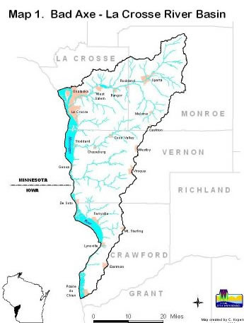
The Bad Axe La Crosse river basin in southwest Wisconsin contains numerous scenic vistas from hilltops and beautiful stream valleys. This basin's steep-forested hillsides coexist with agricultural activities located mainly in the relatively level valleys. The last glaciers to flatten Wisconsin did not reach this part of the state. Consequently, this basin is drained by a highly intricate network of primarily cold, groundwater-fed streams.
The Bad Axe River is tributary to the Mississippi, feeding this great river directly on the western shores of Wisconsin. The Bad Axe basin is often grouped with the La Crosse, Buffalo, Trempeleau basins and is part of the Great Western Rivers area of Wisconsin. Portions of Crawford, La Crosse, Monroe and Vernon counties lie within the Bad Axe - La Crosse River basin. The basin contains 400 hundred miles of trout streams. These coldwater streams are generally in good shape, but urban and rural stormwater runoff, barnyard runoff and inadequate sod cover on streambanks contribute to water quality problems.
WATER RESOURCE INFORMATION FOR SPECIFIC WATERSHEDS
| Watershed name/view details | Watershed size | Lists (streams, lakes, bays & harbors) | Counties | Water management unit (WMU) | Major drainage system |
|---|---|---|---|---|---|
| Bad Axe River | 195.49 mi 2 | BL02 Water lists | Vernon | Bad Axe - La Crosse | Mississippi River |
| Coon Creek | 238.2 mi 2 | BL03 Water lists | La Crosse, Monroe, Vernon | Bad Axe - La Crosse | Mississippi River |
| Little La Crosse River | 240.79 mi 2 | BL05 Water lists | La Crosse, Monroe | Bad Axe - La Crosse | Mississippi River |
| Lower La Crosse River | 145.46 mi 2 | BL04 Water lists | La Crosse | Bad Axe - La Crosse | Mississippi River |
| Rush Creek | 240.16 mi 2 | BL01 Water lists | Crawford, Grant, Vernon | Bad Axe - La Crosse | Mississippi River |
| Upper La Crosse River | 126.12 mi 2 | BL06 Water lists | Monroe | Bad Axe - La Crosse | Mississippi River |
Projects
The Mississippi River, Neshoc Lake, Gill Coulee Creek, Adams Valley, Angelo Pond, Squaw Creek and an unnamed creek are currently on the state's list of impaired waters. Most of these waters are listed for sedimentation of the stream bottom and loss of instream habitat. Search impaired water details.
Watershed plans
Two watershed plans have been updated in this basin. These documents are updates to the Bad Axe La Crosse basin plan (see below).
More information
For more on the Bad Axe La Crosse basin, contact the West Central DNR Staff