Maine Wildlife Area

Maine Wildlife Area is in northcentral Outagamie County with the state owning approximately 720 acres.
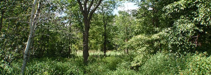
The wildlife area is comprised of extensive wetlands on nearly level terrain, with scattered low upland ridges on fine sand—dune complexes from the margins of extinct glacial lakes. The wetlands consist of sedge meadow, shrub swamp and tamarack bog. The low ridges are forested with aspen, oaks, red maple, paper birch, basswood, green ash and sugar maple.
The acquisition at Maine began in 1942 with the purchase of some tax-delinquent land by the Wisconsin Conservation Commission. The only major development project was the creation of a level ditch, which connects several dug ponds. The property currently is managed for forest and wetland wildlife.
Find Maine Wildlife Area 7 miles north of Shiocton. There is one parking area for the property located on Beyer Road. Access is better under frozen ground conditions.
Management Objectives
The Maine Wildlife Area is managed to provide opportunities for public hunting, trapping and other outdoor recreation while protecting the qualities of the native communities and associated species found on the property. The aspen and oak cover types are maintained along the ridges and opportunities to regenerate both types are pursued through timber management.
For more information on master planning for this and other wildlife areas around the state, visit the property planning page.
Recreation
The Maine Wildlife Area offers many recreational opportunities:
- Birding
- Cross-country skiing (no designated trail)
- Hiking (no designated trail)
- Hunting (noted for deer, grouse and turkey)
- Trapping
- Snowmobiling trail
- A short section of snowmobile trail passes across the property. Access is better under frozen ground conditions.
- Wild edibles/gathering
- Wildlife viewing
Amenities
- Bathroom - none.
- Parking lot - There is one parking area.
- Campground and size - none.
- Trails, Types and Lengths - none.
Maps
Download [PDF] a map of this property.
If you are interested in exploring this property further, you can access an interactive map.
Find out more about how to adopt this wildlife area.

